IMAGES TAKEN NEAR TO
Rydal Court, PENRITH, CA11 8PN
Introduction
This page details the photographs taken nearby to Rydal Court, CA11 8PN by members of the Geograph project.
The Geograph project started in 2005 with the aim of publishing, organising and preserving representative images for every square kilometre of Great Britain, Ireland and the Isle of Man.

There are currently over 7.5m images from over14,400 individuals and you can help contribute to the project by visiting https://www.geograph.org.uk
Image Map
Images are licensed for reuse under creativecommons.org/licenses/by-sa/2.0
Notes
- Clicking on the map will re-center to the selected point.
- The higher the marker number, the further away the image location is from the centre of the postcode.
Image Listing (24 Images Found)
Images are licensed for reuse under creativecommons.org/licenses/by-sa/2.0
Image
Details
Distance
1
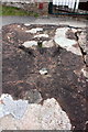
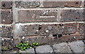
Benchmark at entrance to cricket club
Ordnance Survey rivet benchmark described on the Bench Mark Database at http://www.bench-marks.org.uk/bm68901
Image: © Roger Templeman
Taken: 14 Jul 2015
0.09 miles
2
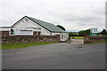
Entrance to Penrith Cricket Club on Wetheriggs Lane
There is an OS benchmark Image on top of the right hand wall end pier
Image: © Roger Templeman
Taken: 14 Jul 2015
0.09 miles
3
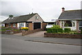
Semi-detached houses on Huntley Avenue
The party wall between the two houses appears to have been rebuilt since there was an OS benchmark on the end pier (gatepost). One of the bricks bearing the mark is now incorporated in the wall behind the present pier Image
Image: © Roger Templeman
Taken: 14 Jul 2015
0.11 miles
4
Benchmark on party wall between nos. 22 and 24 Huntley Avenue
Ordnance Survey cut mark benchmark described on the Bench Mark Database at http://www.bench-marks.org.uk/bm69075
Image: © Roger Templeman
Taken: 14 Jul 2015
0.12 miles
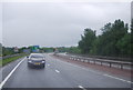
6
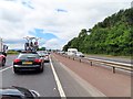
View from the cycle path
A dual carriageway section of the A66 skirting the southern edge of Penrith, linking Junction 40 on the M6 with the roundabout near Carleton Hall which gives access to the A6 and A689.
Image: © Oliver Dixon
Taken: 21 Jul 2016
0.18 miles
8
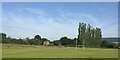
Derelict barn near a rugby pitch
On the southern outskirts of Penrich
Image: © Eirian Evans
Taken: 21 Sep 2020
0.19 miles
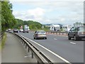
9

A66 westbound
Towards Junction 40, M6 Motorway.
Image: © JThomas
Taken: 22 Oct 2016
0.19 miles