IMAGES TAKEN NEAR TO
Pategill Road, PENRITH, CA11 8JT
Introduction
This page details the photographs taken nearby to Pategill Road, CA11 8JT by members of the Geograph project.
The Geograph project started in 2005 with the aim of publishing, organising and preserving representative images for every square kilometre of Great Britain, Ireland and the Isle of Man.

There are currently over 7.5m images from over14,400 individuals and you can help contribute to the project by visiting https://www.geograph.org.uk
Image Map
Images are licensed for reuse under creativecommons.org/licenses/by-sa/2.0
Notes
- Clicking on the map will re-center to the selected point.
- The higher the marker number, the further away the image location is from the centre of the postcode.
Image Listing (23 Images Found)
Images are licensed for reuse under creativecommons.org/licenses/by-sa/2.0
Image
Details
Distance
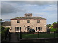
1
Farmhouse conversion at Pategill Farm, Carleton Road
Before conversion there was an Ordnance Survey benchmark on the building, see http://www.bench-marks.org.uk/bm67103 for details
Image: © Roger Templeman
Taken: 3 Jul 2015
0.13 miles
2
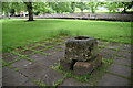
Plague Stone
Grade II* listed. https://historicengland.org.uk/listing/the-list/list-entry/1137825
Image: © N Chadwick
Taken: 23 May 2022
0.14 miles
3
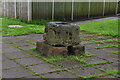
Plague Stone
Grade II* listed. https://historicengland.org.uk/listing/the-list/list-entry/1137825
Image: © N Chadwick
Taken: 23 May 2022
0.14 miles
4
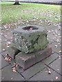
Old Wayside Cross near Bridge Lane, Penrith Parish
Plague Cross, old base by the wayside, in parish of Penrith (Eden District), in grounds of Greengarth Old Peoples' Home, Bridge Lane, beside footpath from Bridge Lane to Tynefield Drive.
Surveyed (Grade II Listed)
Milestone Society National ID: CBED_PEN02
Image: © Milestone Society
Taken: 14 Oct 2017
0.14 miles
5
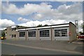
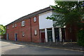
Penrith fire station
Penrith fire station, Bridge Lane, Penrith, Cumbria
Image: © Kevin Hale
Taken: 28 May 2010
0.15 miles
6

Benchmark on Bridge Lane wall
Ordnance Survey cut mark benchmark described on the Bench Mark Database at http://www.bench-marks.org.uk/bm69074
Image: © Roger Templeman
Taken: 14 Jul 2015
0.16 miles
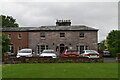
7
Tynefield House, Penrith
Built by the Rimington family who were Quakers in 1804.
Image: © Jonathan Thacker
Taken: 9 May 2011
0.16 miles
9

View across Bridge Lane to college playing fields
There is an OS benchmark Image on the stone wall about 5 yards right of the wall junction
Image: © Roger Templeman
Taken: 14 Jul 2015
0.16 miles
10
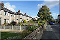
Semi-detached houses along Carleton Road
Housing on Carleton Road in Penrith looking to the east.
Image: © Trevor Littlewood
Taken: 28 Oct 2022
0.17 miles