IMAGES TAKEN NEAR TO
Magnolia Drive, PENRITH, CA11 8FH
Introduction
This page details the photographs taken nearby to Magnolia Drive, CA11 8FH by members of the Geograph project.
The Geograph project started in 2005 with the aim of publishing, organising and preserving representative images for every square kilometre of Great Britain, Ireland and the Isle of Man.

There are currently over 7.5m images from over14,400 individuals and you can help contribute to the project by visiting https://www.geograph.org.uk
Image Map
Images are licensed for reuse under creativecommons.org/licenses/by-sa/2.0
Notes
- Clicking on the map will re-center to the selected point.
- The higher the marker number, the further away the image location is from the centre of the postcode.
Image Listing (13 Images Found)
Images are licensed for reuse under creativecommons.org/licenses/by-sa/2.0
Image
Details
Distance
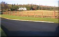
1
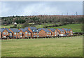
New housing in Penrith
Recently built brick housing on what was a greenfield site; currently, March 2020, OS mapping doesn't show the development.
The trees above are on Beacon Hill.
Image: © Trevor Littlewood
Taken: 9 Mar 2020
0.13 miles
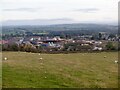
2
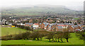
Hedge descending through field
A view over the eastern side of Penrith from Beacon Edge with the Lake District mountains beyond.
Image: © Trevor Littlewood
Taken: 22 Feb 2017
0.14 miles
3
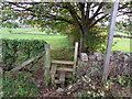
Stile and footpath near Penrith
The stile gives walkers access to the footpath that takes them to Cold Springs and Scaws.
Image: © Maigheach-gheal
Taken: 16 Oct 2010
0.14 miles
4
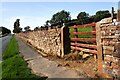
Looking west along Beacon Edge
There is an Ordnance Survey benchmark Image on the road face of the gatepost at the far side of the gateway
Image: © Roger Templeman
Taken: 18 Sep 2020
0.15 miles
5
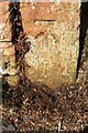
Benchmark on gatepost at gateway on north side of Beacon Edge
Ordnance Survey cut mark benchmark levelled at 202.702m above Newlyn Datum verified 1972
Image: © Roger Templeman
Taken: 18 Sep 2020
0.16 miles
6
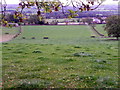
Fields on the edge of Penrith
New houses being built below.
Image: © Richard Webb
Taken: 8 Oct 2021
0.17 miles
7
The White House Penrith.
A private gated road leads up to this house complete with helipad.
Image: © John Holmes
Taken: 4 Jan 2006
0.18 miles
8
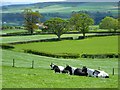
Pasture, Penrith
A view across the Eamont valley from a footpath above Carleton.
Image: © Andrew Smith
Taken: 22 May 2013
0.18 miles
9
Fields near Penrith
The footpath towards Carleton and Scaws follows the fence line of this field.
Image: © Maigheach-gheal
Taken: 16 Oct 2010
0.19 miles
10
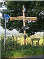
Cumberland CC Fingerpost and C2C Signage
Traditional Cumberland CC fingerpost with supplementary signpost marking out part of the "Coast to Coast" (C2C) cycle route.
Image: © Marshall Renwick
Taken: 3 Aug 2013
0.21 miles