IMAGES TAKEN NEAR TO
Salkeld Road, PENRITH, CA11 8BP
Introduction
This page details the photographs taken nearby to Salkeld Road, CA11 8BP by members of the Geograph project.
The Geograph project started in 2005 with the aim of publishing, organising and preserving representative images for every square kilometre of Great Britain, Ireland and the Isle of Man.

There are currently over 7.5m images from over14,400 individuals and you can help contribute to the project by visiting https://www.geograph.org.uk
Image Map
Images are licensed for reuse under creativecommons.org/licenses/by-sa/2.0
Notes
- Clicking on the map will re-center to the selected point.
- The higher the marker number, the further away the image location is from the centre of the postcode.
Image Listing (13 Images Found)
Images are licensed for reuse under creativecommons.org/licenses/by-sa/2.0
Image
Details
Distance
1
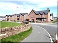
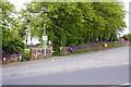
Centurion Rise
New housing estate off Salkeld Road. Named for the fact that it lies along the line of an old Roman Road.
Image: © Oliver Dixon
Taken: 7 Oct 2020
0.04 miles
2
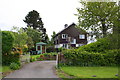
Entrance to #56 Salkeld Road
There is an Ordnance Survey cut mark benchmark on the inside face of the left hand gatepost, hidden by vegetation, see http://www.bench-marks.org.uk/bm88874
Image: © Roger Templeman
Taken: 30 May 2015
0.05 miles
3
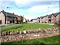
Centurion Rise
New housing estate off Salkeld Road. Named for the fact that it lies along the line of an old Roman Road.
Image: © Oliver Dixon
Taken: 7 Oct 2020
0.05 miles
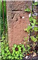
4

Benchmark on boulder at base of Salkeld Road wall
Ordnance Survey cut mark benchmark described on the Bench Mark Database at http://www.bench-marks.org.uk/bm67458
Image: © Roger Templeman
Taken: 30 May 2015
0.10 miles
5
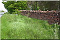
Dry stone wall beside Salkeld Road
There is an OS benchmark Image on the large base stone in the wall near the right hand edge of the image
Image: © Roger Templeman
Taken: 30 May 2015
0.11 miles
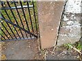
6
Entrance to Fair Hill playing field from Salkeld Road
There is an OS benchmark Image on the right hand gatepost of the left hand gateway
Image: © Roger Templeman
Taken: 30 May 2015
0.18 miles
7
Benchmark on gatepost at Salkeld Road entrance to Fair Hill
Ordnance Survey cut mark benchmark described on the Bench Mark Database at http://www.bench-marks.org.uk/bm67457
Image: © Roger Templeman
Taken: 30 May 2015
0.18 miles
8
Ordnance Survey Cut Mark
This OS cut mark can be found on the park gatepost west side of the road junction. It marks a point 186.946m above mean sea level.
Image: © Adrian Dust
Taken: 14 Sep 2022
0.18 miles
9

The putting area.
The putting area is just outside the clubhouse where we all should be when the sun is shining like this.
Image: © John Holmes
Taken: 4 Jan 2006
0.19 miles
10
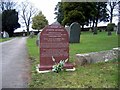
Penrith Cemetery
The headstone pictured is that of PC Joseph Byrnes who was killed at Plumpton in October 1885 - see memorial in gridsquare NY4937
Image: © Brian Norman
Taken: 11 Mar 2008
0.20 miles