IMAGES TAKEN NEAR TO
Beacon Edge, PENRITH, CA11 8BL
Introduction
This page details the photographs taken nearby to Beacon Edge, CA11 8BL by members of the Geograph project.
The Geograph project started in 2005 with the aim of publishing, organising and preserving representative images for every square kilometre of Great Britain, Ireland and the Isle of Man.

There are currently over 7.5m images from over14,400 individuals and you can help contribute to the project by visiting https://www.geograph.org.uk
Image Map
Images are licensed for reuse under creativecommons.org/licenses/by-sa/2.0
Notes
- Clicking on the map will re-center to the selected point.
- The higher the marker number, the further away the image location is from the centre of the postcode.
Image Listing (19 Images Found)
Images are licensed for reuse under creativecommons.org/licenses/by-sa/2.0
Image
Details
Distance
1
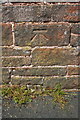
Benchmark on Beacon Edge wall
Ordnance Survey cut mark benchmark described on the Bench Mark Database at http://www.bench-marks.org.uk/bm68367
Image: © Roger Templeman
Taken: 30 May 2015
0.02 miles
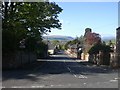
2
Stone wall on north side of Beacon Edge
There is an OS benchmark Image on the wall right of the trunk of the pine tree
Image: © Roger Templeman
Taken: 30 May 2015
0.04 miles
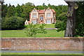
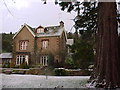
3

Penrith Youth Hostel
Nandana. This lovely old house was sold by the YHA in 1971 for £9500. In 2005 it was sold for £910,000.
Image: © norman griffin
Taken: 17 Apr 1965
0.06 miles
4
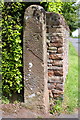
Benchmark on gatepost at entrance to Caroline Cottage, Beacon Edge
Ordnance Survey cut mark benchmark described on the Bench Mark Database at http://www.bench-marks.org.uk/bm67160
Image: © Roger Templeman
Taken: 30 May 2015
0.11 miles
5
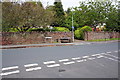
Entrance to Caroline Cottage, Beacon Edge at Fell Lane junction
There is an OS benchmark Image on the gatepost at the far side of the entrance
Image: © Roger Templeman
Taken: 30 May 2015
0.12 miles
6
Penrith - Beacon Hill
Day 2 of the C2C started with a big climb out of Penrith
Image: © easthantsxc
Taken: 15 May 2011
0.12 miles
8

Pasture, Penrith
Cattle below Beacon Edge beside the footpath east of Scaws.
Image: © Andrew Smith
Taken: 22 May 2013
0.16 miles
9
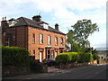
Houses in Fell Lane Penrith
A pair of substantial sandstone semis.
Image: © Rod Allday
Taken: 1 Jun 2011
0.17 miles
10
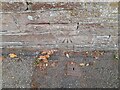
Ordnance Survey Cut Mark
This OS cut mark can be found on the wall SE side of Fell Lane. It marks a point 177.438m above mean sea level.
Image: © Adrian Dust
Taken: 14 Sep 2022
0.17 miles