IMAGES TAKEN NEAR TO
Fell Lane, PENRITH, CA11 8AQ
Introduction
This page details the photographs taken nearby to Fell Lane, CA11 8AQ by members of the Geograph project.
The Geograph project started in 2005 with the aim of publishing, organising and preserving representative images for every square kilometre of Great Britain, Ireland and the Isle of Man.

There are currently over 7.5m images from over14,400 individuals and you can help contribute to the project by visiting https://www.geograph.org.uk
Image Map
Images are licensed for reuse under creativecommons.org/licenses/by-sa/2.0
Notes
- Clicking on the map will re-center to the selected point.
- The higher the marker number, the further away the image location is from the centre of the postcode.
Image Listing (59 Images Found)
Images are licensed for reuse under creativecommons.org/licenses/by-sa/2.0
Image
Details
Distance
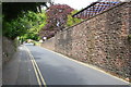
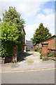
2
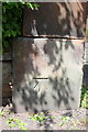
Benchmark on house at Brent Road/Fell Lane junction
Ordnance Survey cut mark benchmark described on the Bench Mark Database at http://www.bench-marks.org.uk/bm68671
Image: © Roger Templeman
Taken: 30 May 2015
0.06 miles
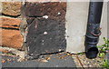
3
House at Fell Lane / Brent Road junction
There is an OS benchmark Image on the near corner of the house left of the black downpipe
Image: © Roger Templeman
Taken: 30 May 2015
0.06 miles
4
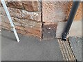
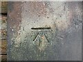
Ordnance Survey Cut Mark
This OS cut mark (or possibly a copy) can be found on the building NE side of Brent Road. It marks a point 159.764m above mean sea level.
Image: © Adrian Dust
Taken: 14 Sep 2022
0.06 miles
5
Benchmark on gatepost at entrance to #21 Arthur Street
Ordnance Survey cut mark benchmark described on the Bench Mark Database at http://www.bench-marks.org.uk/bm38752
Image: © Roger Templeman
Taken: 30 May 2015
0.15 miles
6
Ordnance Survey Cut Mark
This OS cut mark can be found on the gatepost of No21 Arthur Street. It marks a point 148.319m above mean sea level.
Image: © Adrian Dust
Taken: 14 Sep 2022
0.16 miles
7
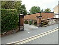
Gateway, Stone House
The substantial red sandstone gateposts of Stone House, 21 Arthur Street.
There is an Ordnance Survey cut benchmark visible on the left hand gatepost.
Image: © Adrian Taylor
Taken: 9 Sep 2020
0.16 miles
8
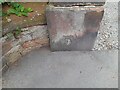
Benchmark, 21 Arthur Street
Detail of the Ordnance Survey cut benchmark at the base of the sandstone gatepost of Stone House, Arthur Street. The benchmark marks a height of 148.319m above sea level (Ordnance Datum Newlyn) last verified in 1972.
Image: © Adrian Taylor
Taken: 9 Sep 2020
0.16 miles
9
Entrance to 'Stone House', #21 Arthur Street
There is an OS benchmark Image on the left hand gatepost
Image: © Roger Templeman
Taken: 30 May 2015
0.16 miles
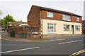
10

Zion Chapel, Fell Lane at Benson Row junction
There is an OS benchmark Image on the chapel wall left of the keep right sign
Image: © Roger Templeman
Taken: 30 May 2015
0.17 miles