IMAGES TAKEN NEAR TO
St. Andrews Churchyard, PENRITH, CA11 7YE
Introduction
This page details the photographs taken nearby to St. Andrews Churchyard, CA11 7YE by members of the Geograph project.
The Geograph project started in 2005 with the aim of publishing, organising and preserving representative images for every square kilometre of Great Britain, Ireland and the Isle of Man.

There are currently over 7.5m images from over14,400 individuals and you can help contribute to the project by visiting https://www.geograph.org.uk
Image Map
Images are licensed for reuse under creativecommons.org/licenses/by-sa/2.0
Notes
- Clicking on the map will re-center to the selected point.
- The higher the marker number, the further away the image location is from the centre of the postcode.
Image Listing (444 Images Found)
Images are licensed for reuse under creativecommons.org/licenses/by-sa/2.0
Image
Details
Distance
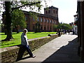
1
Penrith Library
It is located at St. Andrews Churchyard, Penrith
Image: © Kenneth Allen
Taken: 8 Oct 2009
0.00 miles
2
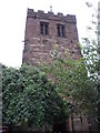
The tower of St Andrew's Church Penrith
This tower is from the original 13th century church which stood on the site it has walls six feet thick
Image: © PAUL FARMER
Taken: 24 Sep 2009
0.00 miles
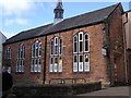
4
Former school, now a library
By the side of St. Andrew's Churchyard, the red sandstone building (constructed 1857) was occupied by the Queen Elizabeth Grammar School until it moved to its present site in 1915. The old school is now part of Penrith Library.
Image: © Rose and Trev Clough
Taken: 11 May 2011
0.01 miles
5
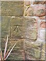
Ordnance Survey Bolt
This bolt can be found at St Andrew's Church, Penrith, Cumbria. These bolts were used by Ordnance Survey for mapping purposes.
Image
Image: © V1ncenze
Taken: 13 May 2021
0.01 miles
6
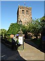
Tower of St Andrew's church
Tower of St Andrew's church in Penrith.
Image: © Philip Halling
Taken: 17 Aug 2016
0.01 miles
7
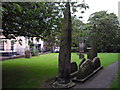
The Giant's Grave Penrith
The Giant's Grave is said, to be the last resting place of Owen Caesarius, King of Cumbria from 920 to 937AD.
Image: © PAUL FARMER
Taken: 24 Sep 2009
0.01 miles
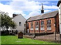
8
Benchmark, St. Andrew's Church
Detail of the Ordnance Survey 1GL Published Abstract Bolt benchmark on the northwest buttress of St. Andrew's Church tower. The benchmark marks a height of 131.9524m above mean sea level (Ordnance Datum Newlyn), last verified in 1972 (location photograph Image).
Image: © Adrian Taylor
Taken: 13 Aug 2020
0.01 miles
9

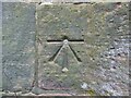
Flower boxes, St. Andrew's Church
Flower boxes at the bottom of the tower beside the west door of St. Andrew's Church.
There is an Ordnance Survey bolt benchmark on the wall above the left hand flower box (detail photograph Image).
Image: © Adrian Taylor
Taken: 13 Aug 2020
0.01 miles
10

Inside the Devonshire Arcade, Penrith
A Victorian market hall, some of the stalls still selling fresh food although most of the units now host a variety of shops and other businesses
Image: © Stephen Craven
Taken: 16 Sep 2020
0.02 miles