IMAGES TAKEN NEAR TO
Nicholson Lane, PENRITH, CA11 7UL
Introduction
This page details the photographs taken nearby to Nicholson Lane, CA11 7UL by members of the Geograph project.
The Geograph project started in 2005 with the aim of publishing, organising and preserving representative images for every square kilometre of Great Britain, Ireland and the Isle of Man.

There are currently over 7.5m images from over14,400 individuals and you can help contribute to the project by visiting https://www.geograph.org.uk
Image Map (Loading...)


Getting Data...Please wait
Leaflet Map data © OpenStreetMap
Images are licensed for reuse under creativecommons.org/licenses/by-sa/2.0
Notes
- Clicking on the map will re-center to the selected point.
- The higher the marker number, the further away the image location is from the centre of the postcode.
Image Listing (32 Images Found)
Images are licensed for reuse under creativecommons.org/licenses/by-sa/2.0
Image
Details
Distance
1
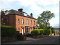
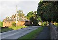
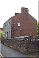
Houses in Fell Lane Penrith
A pair of substantial sandstone semis.
Image: © Rod Allday
Taken: 1 Jun 2011
0.10 miles
2
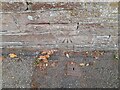
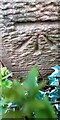
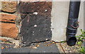
Ordnance Survey Cut Mark
This OS cut mark can be found on the wall SE side of Fell Lane. It marks a point 177.438m above mean sea level.
Image: © Adrian Dust
Taken: 14 Sep 2022
0.10 miles
3
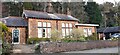
Wall of 'Fir Bank', Fell Lane
There is an OS benchmark Image on a stone in the wall near the left hand edge of the image
Image: © Roger Templeman
Taken: 30 May 2015
0.10 miles
4
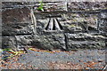
Benchmark on Fell Lane wall
Ordnance Survey cut mark benchmark described on the Bench Mark Database at http://www.bench-marks.org.uk/bm68670
Image: © Roger Templeman
Taken: 30 May 2015
0.10 miles
5
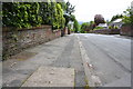
Entering Penrith travelling West along Beacon Edge
This is part of the "Coast to Coast" (C2C) cycle route.
Image: © Marshall Renwick
Taken: 3 Aug 2013
0.12 miles
6
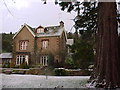
Houses at Jubilee Lodge
There is an Ordnance Survey benchmark Image on the front of the left hand house on the corner right of the door
Image: © Roger Templeman
Taken: 1 Apr 2022
0.13 miles
7
Benchmark on #2 Jubilee Lodge
Ordnance Survey cut mark benchmark levelled at 187.850m above Newlyn Datum verified 1972
Image: © Roger Templeman
Taken: 1 Apr 2022
0.13 miles
9
Beacon Street houses
There is an OS benchmark Image on the wall angle in the foreground
Image: © Roger Templeman
Taken: 30 May 2015
0.14 miles
10
Benchmark on house at Brent Road/Fell Lane junction
Ordnance Survey cut mark benchmark described on the Bench Mark Database at http://www.bench-marks.org.uk/bm68671
Image: © Roger Templeman
Taken: 30 May 2015
0.14 miles