IMAGES TAKEN NEAR TO
Hunters Lane, PENRITH, CA11 7UE
Introduction
This page details the photographs taken nearby to Hunters Lane, CA11 7UE by members of the Geograph project.
The Geograph project started in 2005 with the aim of publishing, organising and preserving representative images for every square kilometre of Great Britain, Ireland and the Isle of Man.

There are currently over 7.5m images from over14,400 individuals and you can help contribute to the project by visiting https://www.geograph.org.uk
Image Map
Images are licensed for reuse under creativecommons.org/licenses/by-sa/2.0
Notes
- Clicking on the map will re-center to the selected point.
- The higher the marker number, the further away the image location is from the centre of the postcode.
Image Listing (407 Images Found)
Images are licensed for reuse under creativecommons.org/licenses/by-sa/2.0
Image
Details
Distance
1
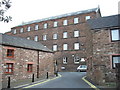
Clint Mill Penrith
The converted mill now houses offices including the local probation service
Image: © PAUL FARMER
Taken: 24 Sep 2009
0.02 miles
2

Coach House Flowers, Penrith
It is located at Burrowgate
Image: © Kenneth Allen
Taken: 8 Oct 2009
0.03 miles
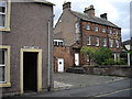
3

Police Station, Hunter's Lane
There is an OS benchmark Image on the gatepost at the near side of the road junction
Image: © Roger Templeman
Taken: 30 May 2015
0.03 miles
4
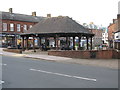
Market Cross, Penrith
In 1983 the central area of Cornmarket was pedestrianised and the ‘market cross’ bandstand was built.
Image: © G Laird
Taken: 6 Jul 2017
0.03 miles
5
Entrance to Scott Yard Penrith
The entrance is in Hunter Lane
Image: © PAUL FARMER
Taken: 23 Sep 2009
0.03 miles
6
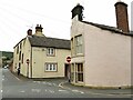
Hunter Lane and Albert Street, Penrith
The curved building to the right (17 Queen Street) dates from the 18th century and is grade II listed (list entry 1326935). See also Image
Image: © Stephen Craven
Taken: 16 Sep 2020
0.03 miles
7

Ordnance Survey Cut Mark
This OS cut mark can be found on the post NW side of Hunters Lane. It marks a point 131.740m above mean sea level.
Image: © Adrian Dust
Taken: 14 Sep 2022
0.03 miles
8

Benchmark on post in Hunter's Lane
Ordnance Survey cut mark benchmark described on the Bench Mark Database at http://www.bench-marks.org.uk/bm67449
Image: © Roger Templeman
Taken: 30 May 2015
0.03 miles
9
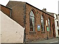
Gospel Hall, Queen Street, Penrith
A Christian Brethren place of worship.
Image: © Stephen Craven
Taken: 16 Sep 2020
0.03 miles
10
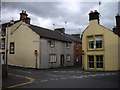
Houses at junction of Hunter Lane and Albert Street Penrith
The picture is taken from Corney Place
Image: © PAUL FARMER
Taken: 23 Sep 2009
0.03 miles