IMAGES TAKEN NEAR TO
Croft Avenue, PENRITH, CA11 7RG
Introduction
This page details the photographs taken nearby to Croft Avenue, CA11 7RG by members of the Geograph project.
The Geograph project started in 2005 with the aim of publishing, organising and preserving representative images for every square kilometre of Great Britain, Ireland and the Isle of Man.

There are currently over 7.5m images from over14,400 individuals and you can help contribute to the project by visiting https://www.geograph.org.uk
Image Map
Images are licensed for reuse under creativecommons.org/licenses/by-sa/2.0
Notes
- Clicking on the map will re-center to the selected point.
- The higher the marker number, the further away the image location is from the centre of the postcode.
Image Listing (148 Images Found)
Images are licensed for reuse under creativecommons.org/licenses/by-sa/2.0
Image
Details
Distance
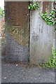
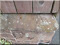
1
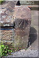
Benchmark on gatepost of #136 Graham Street
Ordnance Survey pivot benchmark described on the Bench Mark Database at http://www.bench-marks.org.uk/bm67451
Image: © Roger Templeman
Taken: 30 May 2015
0.03 miles
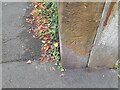
2
Ordnance Survey Pivot
This OS pivot can be found on the gatepost of No136 Graham Street. It marks a point 139.693m above mean sea level.
Image: © Adrian Dust
Taken: 14 Sep 2022
0.03 miles
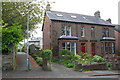
3
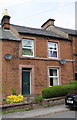
#136 Graham Street
There is an OS benchmark Image on the left hand gatepost at the house entrance
Image: © Roger Templeman
Taken: 30 May 2015
0.04 miles
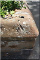
4
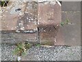
Benchmark on gatepost beside footpath from Graham Street
Ordnance Survey cut mark benchmark described on the Bench Mark Database at http://www.bench-marks.org.uk/bm67452
Image: © Roger Templeman
Taken: 30 May 2015
0.08 miles
5
Footpath from Graham Street
There is an OS benchmark Image on the gatepost at the right hand side of footpath
Image: © Roger Templeman
Taken: 30 May 2015
0.08 miles
6
Ordnance Survey Cut Mark
This OS cut mark can be found on the wall post at the angle of path and Graham Street. It marks a point 152.182m above mean sea level.
Image: © Adrian Dust
Taken: 14 Sep 2022
0.08 miles
7
Benchmark on wall at junction of Graham Street and Drovers Lane
Ordnance Survey pivot benchmark described on the Bench Mark Database at http://www.bench-marks.org.uk/bm38746
Image: © Roger Templeman
Taken: 26 May 2015
0.09 miles
8
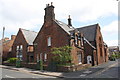
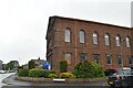
Old School House at junction of Graham Street and Drovers Lane
There is an OS benchmark Image on the corner of the boundary wall of the former school
Image: © Roger Templeman
Taken: 26 May 2015
0.09 miles
9
Ordnance Survey Pivot
This OS pivot can be found at the junction of Graham Street and Drover Lane. It marks a point 136.757m above mean sea level.
Image: © Adrian Dust
Taken: 14 Sep 2022
0.09 miles