IMAGES TAKEN NEAR TO
Wordsworth Street, PENRITH, CA11 7QX
Introduction
This page details the photographs taken nearby to Wordsworth Street, CA11 7QX by members of the Geograph project.
The Geograph project started in 2005 with the aim of publishing, organising and preserving representative images for every square kilometre of Great Britain, Ireland and the Isle of Man.

There are currently over 7.5m images from over14,400 individuals and you can help contribute to the project by visiting https://www.geograph.org.uk
Image Map
Images are licensed for reuse under creativecommons.org/licenses/by-sa/2.0
Notes
- Clicking on the map will re-center to the selected point.
- The higher the marker number, the further away the image location is from the centre of the postcode.
Image Listing (65 Images Found)
Images are licensed for reuse under creativecommons.org/licenses/by-sa/2.0
Image
Details
Distance
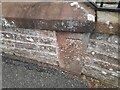
1
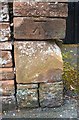
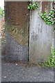
Benchmark on angle of wall, Beacon Street
Ordnance Survey cut mark benchmark described on the Bench Mark Database at http://www.bench-marks.org.uk/bm67450
Image: © Roger Templeman
Taken: 30 May 2015
0.05 miles
2
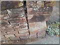
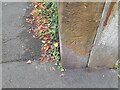
Ordnance Survey Cut Mark
This OS cut mark can be found on the wall SW side of Beacon Street. It marks a point 169.257m above mean sea level.
Image: © Adrian Dust
Taken: 14 Sep 2022
0.05 miles
3
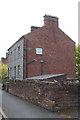
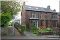
Beacon Street houses
There is an OS benchmark Image on the wall angle in the foreground
Image: © Roger Templeman
Taken: 30 May 2015
0.06 miles
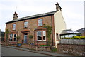
4
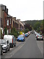
Wordsworth Street Penrith
Looking up the hill towards Beacon Hill.
Image: © Rod Allday
Taken: 1 Jun 2011
0.07 miles
5
Footpath from Graham Street
There is an OS benchmark Image on the gatepost at the right hand side of footpath
Image: © Roger Templeman
Taken: 30 May 2015
0.10 miles
6
Benchmark on gatepost beside footpath from Graham Street
Ordnance Survey cut mark benchmark described on the Bench Mark Database at http://www.bench-marks.org.uk/bm67452
Image: © Roger Templeman
Taken: 30 May 2015
0.11 miles
7
Ordnance Survey Cut Mark
This OS cut mark can be found on the wall post at the angle of path and Graham Street. It marks a point 152.182m above mean sea level.
Image: © Adrian Dust
Taken: 14 Sep 2022
0.11 miles
8
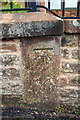
Benchmark on wall outside 'Blencathra', Graham Street
Ordnance Survey cut mark benchmark described on the Bench Mark Database at http://www.bench-marks.org.uk/bm67453
Image: © Roger Templeman
Taken: 30 May 2015
0.12 miles
9
Ordnance Survey Cut Mark
This OS cut mark can be found on the wall east side of Graham Street. It marks a point 167.514m above mean sea level.
Image: © Adrian Dust
Taken: 14 Sep 2022
0.12 miles
10
'Blencathra', Graham Street
There is an OS benchmark Image on the roadside wall in line with the right hand side of the right hand bay window
Image: © Roger Templeman
Taken: 30 May 2015
0.12 miles