IMAGES TAKEN NEAR TO
Drovers Lane, PENRITH, CA11 7QW
Introduction
This page details the photographs taken nearby to Drovers Lane, CA11 7QW by members of the Geograph project.
The Geograph project started in 2005 with the aim of publishing, organising and preserving representative images for every square kilometre of Great Britain, Ireland and the Isle of Man.

There are currently over 7.5m images from over14,400 individuals and you can help contribute to the project by visiting https://www.geograph.org.uk
Image Map
Images are licensed for reuse under creativecommons.org/licenses/by-sa/2.0
Notes
- Clicking on the map will re-center to the selected point.
- The higher the marker number, the further away the image location is from the centre of the postcode.
Image Listing (258 Images Found)
Images are licensed for reuse under creativecommons.org/licenses/by-sa/2.0
Image
Details
Distance
3
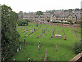
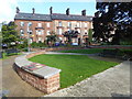
Church yard, Penrith
A view over the churchyard of Christ Church from a back window of a house in Portland Place. Beyond the churchyard wall, the road is Drover's Lane.
Image: © Richard Dorrell
Taken: 10 Sep 2014
0.03 miles
4
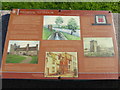
One of the information boards in Coronation Gardens, Penrith
Coronation Gardens were opened on 20th April 1938 in commemoration of the coronation of King George VIth and Queen Elizabeth in May 1937. The garden was upgraded with the assistance of the Heritage Lottery Fund and duly opened in July 2013. There are a very interesting series of information boards of which this is one.
Image: © Marathon
Taken: 25 Aug 2018
0.03 miles
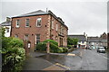
5
Coronation Gardens, Penrith
Coronation Gardens were opened on 20th April 1938 in commemoration of the coronation of King George VIth and Queen Elizabeth in May 1937. The garden was upgraded with the assistance of the Heritage Lottery Fund and duly opened in July 2013. There are a very interesting series of information boards of which this is one - http://www.geograph.org.uk/photo/5916642 The houses beyond are in Portland Place.
Image: © Marathon
Taken: 25 Aug 2018
0.03 miles
7
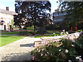
Coronation Gardens, Penrith
Coronation Gardens were opened on 20th April 1938 in commemoration of the coronation of King George VIth and Queen Elizabeth in May 1937. The garden was upgraded with the assistance of the Heritage Lottery Fund and duly opened in July 2013. There are a very interesting series of information boards of which this is one - http://www.geograph.org.uk/photo/5916642 The houses on the left are in Portland Place.
Image: © Marathon
Taken: 25 Aug 2018
0.03 miles
8
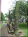
Giants Grave.
Graveyard St. Andrews Church Penrith. NY51653071
Image: © wfmillar
Taken: 16 Jun 2006
0.03 miles
9
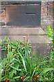
Benchmark on buttress of Christ Church
Ordnance Survey cut mark benchmark described on the Bench Mark Database at http://www.bench-marks.org.uk/bm38747
Image: © Roger Templeman
Taken: 26 May 2015
0.04 miles
10
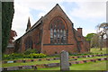
Christ Church with churchyard
There is an OS benchmark Image on the inside face of the buttress on the right hand near corner of the church
Image: © Roger Templeman
Taken: 26 May 2015
0.04 miles