IMAGES TAKEN NEAR TO
Bath Terrace, PENRITH, CA11 7QR
Introduction
This page details the photographs taken nearby to Bath Terrace, CA11 7QR by members of the Geograph project.
The Geograph project started in 2005 with the aim of publishing, organising and preserving representative images for every square kilometre of Great Britain, Ireland and the Isle of Man.

There are currently over 7.5m images from over14,400 individuals and you can help contribute to the project by visiting https://www.geograph.org.uk
Image Map
Images are licensed for reuse under creativecommons.org/licenses/by-sa/2.0
Notes
- Clicking on the map will re-center to the selected point.
- The higher the marker number, the further away the image location is from the centre of the postcode.
Image Listing (349 Images Found)
Images are licensed for reuse under creativecommons.org/licenses/by-sa/2.0
Image
Details
Distance

2

Houses on Arthur Terrace
There is an OS benchmark Image on the 3rd stone post from the left hand side of the image
Image: © Roger Templeman
Taken: 30 May 2015
0.01 miles
3

Benchmark on gatepost at #5 Arthur Terrace
Ordnance Survey cut mark benchmark described on the Bench Mark Database at http://www.bench-marks.org.uk/bm38750
Image: © Roger Templeman
Taken: 30 May 2015
0.02 miles
4

Ordnance Survey Cut Mark
This OS cut mark can be found on the gatepost of No5 Arthur Street. It marks a point 133.471m above mean sea level.
Image: © Adrian Dust
Taken: 14 Sep 2022
0.02 miles
5

Hunter Lane
Looking onto Meetinghouse Lane from Hunter Lane in Penrith.
Image: © DS Pugh
Taken: 11 Jul 2020
0.02 miles


8
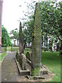
Giants Grave.
Graveyard St. Andrews Church Penrith. NY51653071
Image: © wfmillar
Taken: 16 Jun 2006
0.04 miles
9

Ordnance Survey Cut Mark
This OS cut mark can be found on the post NW side of Hunters Lane. It marks a point 131.740m above mean sea level.
Image: © Adrian Dust
Taken: 14 Sep 2022
0.04 miles
10

Benchmark on post in Hunter's Lane
Ordnance Survey cut mark benchmark described on the Bench Mark Database at http://www.bench-marks.org.uk/bm67449
Image: © Roger Templeman
Taken: 30 May 2015
0.04 miles