IMAGES TAKEN NEAR TO
Hunters Lane, PENRITH, CA11 7PR
Introduction
This page details the photographs taken nearby to Hunters Lane, CA11 7PR by members of the Geograph project.
The Geograph project started in 2005 with the aim of publishing, organising and preserving representative images for every square kilometre of Great Britain, Ireland and the Isle of Man.

There are currently over 7.5m images from over14,400 individuals and you can help contribute to the project by visiting https://www.geograph.org.uk
Image Map
Images are licensed for reuse under creativecommons.org/licenses/by-sa/2.0
Notes
- Clicking on the map will re-center to the selected point.
- The higher the marker number, the further away the image location is from the centre of the postcode.
Image Listing (397 Images Found)
Images are licensed for reuse under creativecommons.org/licenses/by-sa/2.0
Image
Details
Distance
1
Entrance to Scott Yard Penrith
The entrance is in Hunter Lane
Image: © PAUL FARMER
Taken: 23 Sep 2009
0.01 miles
2
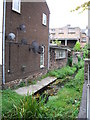
Thacka Beck Penrith
Penrith's first water supply created in the 1400s.
Image: © PAUL FARMER
Taken: 24 Sep 2009
0.01 miles
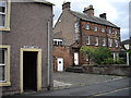
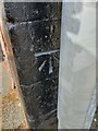
3

Police Station, Hunter's Lane
There is an OS benchmark Image on the gatepost at the near side of the road junction
Image: © Roger Templeman
Taken: 30 May 2015
0.02 miles
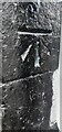
4

Benchmark on post in Hunter's Lane
Ordnance Survey cut mark benchmark described on the Bench Mark Database at http://www.bench-marks.org.uk/bm67449
Image: © Roger Templeman
Taken: 30 May 2015
0.02 miles
5
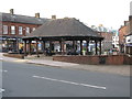
Market Cross, Penrith
In 1983 the central area of Cornmarket was pedestrianised and the ‘market cross’ bandstand was built.
Image: © G Laird
Taken: 6 Jul 2017
0.02 miles
6
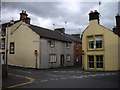
Houses at junction of Hunter Lane and Albert Street Penrith
The picture is taken from Corney Place
Image: © PAUL FARMER
Taken: 23 Sep 2009
0.02 miles
7
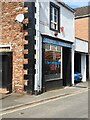
Shop, Penrith, Cumbria
Local TV shop in Penrith, Cumbria, This shop also has an Ordnance Survey bench mark. Image
Image: © V1ncenze
Taken: 13 May 2021
0.02 miles
8
Ordnance Survey Bench Mark
This mark is located on a shop front in Penrith, Cumbria. These marks were used by Ordnance Survey for mapping purposes. Image
Image: © V1ncenze
Taken: 13 May 2021
0.02 miles
9
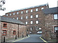
Clint Mill Penrith
The converted mill now houses offices including the local probation service
Image: © PAUL FARMER
Taken: 24 Sep 2009
0.03 miles
10
Benchmark on #18 Queen Street
Ordnance Survey cut mark benchmark levelled at 130.597m above Newlyn Datum verified in 1972
Image: © Roger Templeman
Taken: 1 Apr 2022
0.03 miles