IMAGES TAKEN NEAR TO
Foster Street, PENRITH, CA11 7PA
Introduction
This page details the photographs taken nearby to Foster Street, CA11 7PA by members of the Geograph project.
The Geograph project started in 2005 with the aim of publishing, organising and preserving representative images for every square kilometre of Great Britain, Ireland and the Isle of Man.

There are currently over 7.5m images from over14,400 individuals and you can help contribute to the project by visiting https://www.geograph.org.uk
Image Map
Images are licensed for reuse under creativecommons.org/licenses/by-sa/2.0
Notes
- Clicking on the map will re-center to the selected point.
- The higher the marker number, the further away the image location is from the centre of the postcode.
Image Listing (78 Images Found)
Images are licensed for reuse under creativecommons.org/licenses/by-sa/2.0
Image
Details
Distance

7
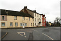
The Acorn Guest House
Beside Scotland Road, Penrith.
Image: © David Rogers
Taken: 22 Jan 2010
0.07 miles

9
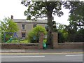
Cockell House, Drover's Lane, Penrith
The green plaque on the fence records "John Macadam General Surveyor of Roads lived here c 1820"
Image: © Oliver Dixon
Taken: 21 Jul 2016
0.08 miles