IMAGES TAKEN NEAR TO
Stricklandgate, PENRITH, CA11 7NJ
Introduction
This page details the photographs taken nearby to Stricklandgate, CA11 7NJ by members of the Geograph project.
The Geograph project started in 2005 with the aim of publishing, organising and preserving representative images for every square kilometre of Great Britain, Ireland and the Isle of Man.

There are currently over 7.5m images from over14,400 individuals and you can help contribute to the project by visiting https://www.geograph.org.uk
Image Map
Images are licensed for reuse under creativecommons.org/licenses/by-sa/2.0
Notes
- Clicking on the map will re-center to the selected point.
- The higher the marker number, the further away the image location is from the centre of the postcode.
Image Listing (183 Images Found)
Images are licensed for reuse under creativecommons.org/licenses/by-sa/2.0
Image
Details
Distance
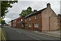
6
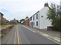
Drovers Lane
Looking along Drovers Lane leading towards the centre of Penrith.
Image: © DS Pugh
Taken: 11 Jul 2020
0.06 miles
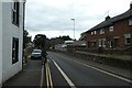
9
Drover's Lane, Penrith
Drover's Lane is one-way south to north, but to accommodate cycle traffic in a southbound direction along National Cycle Route 7 (the world-famous C2C cycle route) a contraflow cycle lane has been installed.
Image: © Oliver Dixon
Taken: 21 Jul 2016
0.07 miles
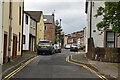
10
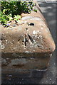
Benchmark on wall at junction of Graham Street and Drovers Lane
Ordnance Survey pivot benchmark described on the Bench Mark Database at http://www.bench-marks.org.uk/bm38746
Image: © Roger Templeman
Taken: 26 May 2015
0.07 miles