IMAGES TAKEN NEAR TO
Stricklandgate, PENRITH, CA11 7NF
Introduction
This page details the photographs taken nearby to Stricklandgate, CA11 7NF by members of the Geograph project.
The Geograph project started in 2005 with the aim of publishing, organising and preserving representative images for every square kilometre of Great Britain, Ireland and the Isle of Man.

There are currently over 7.5m images from over14,400 individuals and you can help contribute to the project by visiting https://www.geograph.org.uk
Image Map
Images are licensed for reuse under creativecommons.org/licenses/by-sa/2.0
Notes
- Clicking on the map will re-center to the selected point.
- The higher the marker number, the further away the image location is from the centre of the postcode.
Image Listing (225 Images Found)
Images are licensed for reuse under creativecommons.org/licenses/by-sa/2.0
Image
Details
Distance
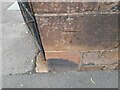
2
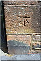
Benchmark on Stricklandgate wall at Christ Church entrance
Ordnance Survey cut mark benchmark described on the Bench Mark Database at http://www.bench-marks.org.uk/bm38745
Image: © Roger Templeman
Taken: 26 May 2015
0.02 miles
3
Ordnance Survey Cut Mark
This OS cut mark can be found on the wall of Christ Church. It marks a point 133.082m above mean sea level.
Image: © Adrian Dust
Taken: 14 Sep 2022
0.02 miles
4
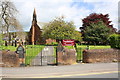
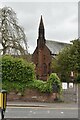
Stricklandgate entrance to Christ Church
There is an OS benchmark Image on the wall pier on the right hand side of the main gates.
Image: © Roger Templeman
Taken: 26 May 2015
0.02 miles
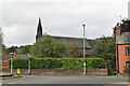
8
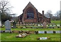
Christ Church Penrith
A Church of England facility with an extensive graveyard.
Image: © Mary and Angus Hogg
Taken: 23 Mar 2016
0.03 miles