IMAGES TAKEN NEAR TO
Castlegate, PENRITH, CA11 7HX
Introduction
This page details the photographs taken nearby to Castlegate, CA11 7HX by members of the Geograph project.
The Geograph project started in 2005 with the aim of publishing, organising and preserving representative images for every square kilometre of Great Britain, Ireland and the Isle of Man.

There are currently over 7.5m images from over14,400 individuals and you can help contribute to the project by visiting https://www.geograph.org.uk
Image Map
Images are licensed for reuse under creativecommons.org/licenses/by-sa/2.0
Notes
- Clicking on the map will re-center to the selected point.
- The higher the marker number, the further away the image location is from the centre of the postcode.
Image Listing (582 Images Found)
Images are licensed for reuse under creativecommons.org/licenses/by-sa/2.0
Image
Details
Distance
1
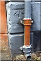
Benchmark on #16 Cornmarket
Ordnance Survey cut mark benchmark described on the Bench Mark Database at http://www.bench-marks.org.uk/bm66982
Image: © Roger Templeman
Taken: 26 May 2015
0.01 miles
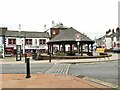
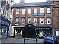
2

Cornmarket, Penrith, Cumbria
Cornmarket in Penrith, Cumbria. Now various shops and office. The building also has an Ordnance Survey bench mark. Image
Image: © V1ncenze
Taken: 13 May 2021
0.01 miles
3
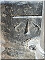
Ordnance Survey Bench Mark
This mark is located on the Cornmarket, Penrith, Cumbria. These marks were used by Ordnance Survey for mapping purposes. Image
Image: © V1ncenze
Taken: 13 May 2021
0.01 miles
4
Ordnance Survey Cut Mark
This OS cut mark can be found on the Central Buildings, Cornmarket. It marks a point 130.854m above mean sea level.
Image: © Adrian Dust
Taken: 14 Sep 2022
0.01 miles
5
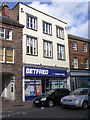
Betfred, Penrith
It is located at Burrowgate
Image: © Kenneth Allen
Taken: 8 Oct 2009
0.02 miles
6
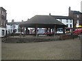
Market Cross, Penrith town centre
This building provides a covered area in Penrith Market Square.
Image: © Graham Robson
Taken: 2 Nov 2009
0.02 miles
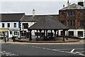
7
Cornmarket, Penrith
The structure in the centre is known as the market cross, although it is actually a covered area for a few market stalls, and is modern (1983). The oddly named 'board and elbow' pub behind was formerly the ‘Black Bull’ and dates from 1624. Source: https://www.explorepenrith.org.uk/trail/stage5/
Image: © Stephen Craven
Taken: 16 Sep 2020
0.02 miles
9
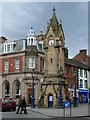
Penrith Clock Tower
The clock tower, in the heart of Penrith, was built in 1861 to commemorate Philip Musgrave of Edenhall.
Image: © Stephen McKay
Taken: 7 Oct 2006
0.02 miles
10
The George Hotel, Penrith
Image: © Nick Mutton 01329 000000
Taken: 24 Feb 2008
0.02 miles