IMAGES TAKEN NEAR TO
Bowling Green Lane, PENRITH, CA11 7GP
Introduction
This page details the photographs taken nearby to Bowling Green Lane, CA11 7GP by members of the Geograph project.
The Geograph project started in 2005 with the aim of publishing, organising and preserving representative images for every square kilometre of Great Britain, Ireland and the Isle of Man.

There are currently over 7.5m images from over14,400 individuals and you can help contribute to the project by visiting https://www.geograph.org.uk
Image Map
Images are licensed for reuse under creativecommons.org/licenses/by-sa/2.0
Notes
- Clicking on the map will re-center to the selected point.
- The higher the marker number, the further away the image location is from the centre of the postcode.
Image Listing (453 Images Found)
Images are licensed for reuse under creativecommons.org/licenses/by-sa/2.0
Image
Details
Distance
1

George Hotel,Penrith
It is located in the centre of the town
Image: © Kenneth Allen
Taken: 2 Aug 2008
0.01 miles

3

Family Grocers, Penrith
Looking south-east
Image: © Kenneth Allen
Taken: 2 Aug 2008
0.01 miles
4
Penrith Building Society
Looking north
Image: © Kenneth Allen
Taken: 2 Aug 2008
0.01 miles
5
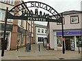
Entrance to New Squares, Penrith
A traffic-free modern shopping area.
Image: © Stephen Craven
Taken: 16 Sep 2020
0.01 miles
6
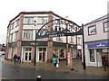
Entrance to New Squares, Penrith
The entrance to the Penrith New Squares shopping development from Princess Street. M & Co and a Hallmark card shop flank the entrance to the pedestrian only area.
Image: © Graham Robson
Taken: 7 Nov 2014
0.02 miles
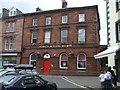
7
Former main post office, Penrith
The post office had recently closed and moved to a smaller site nearby.
Image: © Stephen Craven
Taken: 16 Sep 2020
0.02 miles
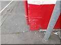
8
Benchmark on #30 King Street
Ordnance Survey cut mark benchmark described on the Bench Mark Database at http://www.bench-marks.org.uk/bm68956
Image: © Roger Templeman
Taken: 14 Jul 2015
0.03 miles
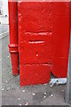
9
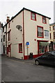
#30 King Street - a sweet shop
There is an OS benchmark Image on the red skirt of the shop on its near corner, right hand face, left of the post of the 'no through road' sign
Image: © Roger Templeman
Taken: 14 Jul 2015
0.03 miles
10
Ordnance Survey Cut Mark
This OS cut mark can be found on No30 King Street. It marks a point 126.059m above mean sea level.
Image: © Adrian Dust
Taken: 14 Sep 2022
0.03 miles