IMAGES TAKEN NEAR TO
Tyne Close Terrace, PENRITH, CA11 7ES
Introduction
This page details the photographs taken nearby to Tyne Close Terrace, CA11 7ES by members of the Geograph project.
The Geograph project started in 2005 with the aim of publishing, organising and preserving representative images for every square kilometre of Great Britain, Ireland and the Isle of Man.

There are currently over 7.5m images from over14,400 individuals and you can help contribute to the project by visiting https://www.geograph.org.uk
Image Map
Images are licensed for reuse under creativecommons.org/licenses/by-sa/2.0
Notes
- Clicking on the map will re-center to the selected point.
- The higher the marker number, the further away the image location is from the centre of the postcode.
Image Listing (128 Images Found)
Images are licensed for reuse under creativecommons.org/licenses/by-sa/2.0
Image
Details
Distance
1

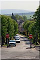
Wetheriggs, Penrith
School playing fields and houses Wetheriggs Rise and Tyne Close Terrace with the clouded Pennines in the background.
Image: © Andrew Smith
Taken: 7 Sep 2012
0.07 miles
2
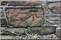
Benchmark on wall at top of steps to Castle Drive
Ordnance Survey cut mark benchmark described on the Bench Mark Database at http://www.bench-marks.org.uk/bm69076
Image: © Roger Templeman
Taken: 14 Jul 2015
0.10 miles
3
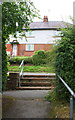
Steps up to Castle Drive
There is an OS benchmark Image on the stone wall on the left hand side of the bottom step
Image: © Roger Templeman
Taken: 14 Jul 2015
0.10 miles
4
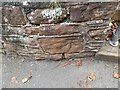
Ordnance Survey Cut Mark
This OS cut mark can be found on the wall SE side of Castle Drive. It marks a point 140.340m above mean sea level.
Image: © Adrian Dust
Taken: 14 Sep 2022
0.10 miles
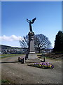
6
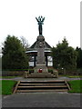
The "Black Angel", Penrith
"In memory of the men of this town and district who fell in the South African war 1899-1902". This Boer War memorial in Castle Park was originally located in Corney Square in front of the Town Hall.
Image: © David Rogers
Taken: 13 Nov 2009
0.12 miles
7
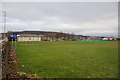
Queen Elizabeth Grammar School, Penrith
Looking across the playing field, with parts of northern Penrith visible beyond.
Image: © Bill Boaden
Taken: 5 Mar 2014
0.12 miles
8
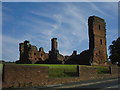
Penrith Castle
Penrith Castle freely open to the public. Located across the road from the railway station so worth a browse whilst you await a train
Image: © Carl Bendelow
Taken: 30 Jul 1999
0.12 miles
9
Penrith Castle
Built 1399-1470 to help defend the town of Penrith from Scottish incursions.
http://en.wikipedia.org/wiki/Penrith,_Cumbria
Image: © Colin Smith
Taken: 1 Aug 1987
0.14 miles
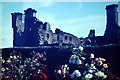
10
War Memorial, Castle Park
Memorial to those who died in the South African War 1899-1902
Image: © Alexander P Kapp
Taken: 17 Apr 2008
0.15 miles