IMAGES TAKEN NEAR TO
St. Andrews Place, PENRITH, CA11 7AW
Introduction
This page details the photographs taken nearby to St. Andrews Place, CA11 7AW by members of the Geograph project.
The Geograph project started in 2005 with the aim of publishing, organising and preserving representative images for every square kilometre of Great Britain, Ireland and the Isle of Man.

There are currently over 7.5m images from over14,400 individuals and you can help contribute to the project by visiting https://www.geograph.org.uk
Image Map
Images are licensed for reuse under creativecommons.org/licenses/by-sa/2.0
Notes
- Clicking on the map will re-center to the selected point.
- The higher the marker number, the further away the image location is from the centre of the postcode.
Image Listing (431 Images Found)
Images are licensed for reuse under creativecommons.org/licenses/by-sa/2.0
Image
Details
Distance
2
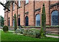
The Giant's Grave
The Giant’s Grave is a group of 10th century tombstones, comprising 2 tall crosses and 4 hogbacks, all carved with intricate designs of Celtic, Anglian and Norse origins. On being opened in the 17th century, the grave revealed human bones and a sword. The hogbacks were originally located in different parts of the churchyard but all were brought together after the excavation. It is thought that Owen, King of Cumbria between A.D. 920 and 937, may be buried here. However, local legends suggest that the grave could be for Sir Owen Caesarius. (Source: St Andrew's churchyard information board)
Image: © Mary and Angus Hogg
Taken: 23 Mar 2016
0.01 miles
4
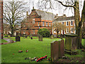
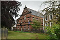
Graveyard of St. Andrew's Church, Penrith
The view is across the graveyard on the south side of the church; the central red-brick building is the Parish Centre.
Image: © Trevor Littlewood
Taken: 17 Jan 2015
0.02 miles
5
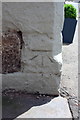
Benchmark on #9A King Street
Ordnance Survey cut mark benchmark described on the Bench Mark Database at http://www.bench-marks.org.uk/bm68611
Image: © Roger Templeman
Taken: 3 Jul 2015
0.02 miles
6
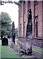
Giant's Grave, St Andrews Penrith (1970)
A curiosity noticed when passing through the area on leave.
Image: © Stanley Howe
Taken: Unknown
0.02 miles
7
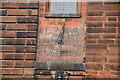
Benchmark, Old Crown Hotel
Ordnance Survey benchmark on the corner of 9A King Street; formerly the Crown Hotel. The benchmark marks a height of 127.4078m above sea level (Ordnance Datum Newlyn) last verified in 1972 (location photograph Image).
Image: © Adrian Taylor
Taken: 13 Aug 2020
0.02 miles
8

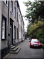
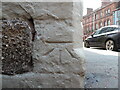
Corner of 9A King Street
9A King Street was formerly the Crown Hotel. There is an Ordnance Survey benchmark on one of the stone quoins (photograph Image).
The A6 road, King Street is in the background.
Image: © Adrian Taylor
Taken: 13 Aug 2020
0.02 miles
9
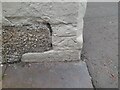
Ordnance Survey Cut Mark
This OS cut mark can be found on No9A King Street. It marks a point 127.408m above mean sea level.
Image: © Adrian Dust
Taken: 14 Sep 2022
0.02 miles