IMAGES TAKEN NEAR TO
King Street, PENRITH, CA11 7AR
Introduction
This page details the photographs taken nearby to King Street, CA11 7AR by members of the Geograph project.
The Geograph project started in 2005 with the aim of publishing, organising and preserving representative images for every square kilometre of Great Britain, Ireland and the Isle of Man.

There are currently over 7.5m images from over14,400 individuals and you can help contribute to the project by visiting https://www.geograph.org.uk
Image Map
Images are licensed for reuse under creativecommons.org/licenses/by-sa/2.0
Notes
- Clicking on the map will re-center to the selected point.
- The higher the marker number, the further away the image location is from the centre of the postcode.
Image Listing (455 Images Found)
Images are licensed for reuse under creativecommons.org/licenses/by-sa/2.0
Image
Details
Distance
2
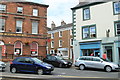
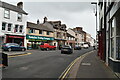
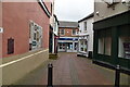
King Street Penrith
The junction with Middlegate and King Street.
Image: © edward mcmaihin
Taken: 29 Jul 2013
0.02 miles
4
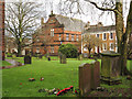
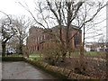
Graveyard of St. Andrew's Church, Penrith
The view is across the graveyard on the south side of the church; the central red-brick building is the Parish Centre.
Image: © Trevor Littlewood
Taken: 17 Jan 2015
0.02 miles
9
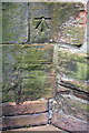
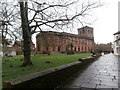
Benchmark on tower of St Andrew's Church
Ordnance Survey 1GL bolt benchmark described on the Bench Mark Database at http://www.bench-marks.org.uk/bm19698. This mark was levelled at 432.648m above Liverpool Datum during the 1841-1844 1GL Liverpool to Port Carlisle Survey. The surveyor's description was 'No. 392. Bolt in North-west corner of Penrith Church tower ; 4.42 ft. above surface'
Image: © Roger Templeman
Taken: 30 May 2015
0.02 miles
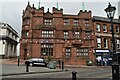
10
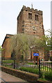
St Andrew's Church
There is an OS benchmark Image on the buttress on the near corner of the tower, whose weather vane is a component of an OS intersected station trig point, http://trigpointing.uk/trig/11264
Image: © Roger Templeman
Taken: 30 May 2015
0.02 miles