IMAGES TAKEN NEAR TO
Troutbeck, PENRITH, CA11 0SU
Introduction
This page details the photographs taken nearby to CA11 0SU by members of the Geograph project.
The Geograph project started in 2005 with the aim of publishing, organising and preserving representative images for every square kilometre of Great Britain, Ireland and the Isle of Man.

There are currently over 7.5m images from over14,400 individuals and you can help contribute to the project by visiting https://www.geograph.org.uk
Image Map
Images are licensed for reuse under creativecommons.org/licenses/by-sa/2.0
Notes
- Clicking on the map will re-center to the selected point.
- The higher the marker number, the further away the image location is from the centre of the postcode.
Image Listing (10 Images Found)
Images are licensed for reuse under creativecommons.org/licenses/by-sa/2.0
Image
Details
Distance
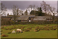
2
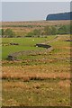
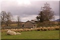
Highgateclose Farm
The hill beyond is Souther Fell Image
Image: © Oliver Dixon
Taken: 10 Dec 2007
0.02 miles
3
Highgateclose
A remote farm near Mosedale.
Image: © Ian Capper
Taken: 11 Apr 2008
0.05 miles
4
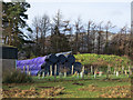
Silage bales at Highgateclose
Highgateclose is a farm below the moorland at the northern end of the Helvellyn range of mountains. Silage is wrapped in plastic sheeting which originally came only in black. Other colours have become available.... various greens, white and then pink (for which a premium price is paid with a contribution going to breast cancer research). A new colour in 2016 - at least new to the photographer - has been purple.
Image: © Trevor Littlewood
Taken: 17 Dec 2016
0.07 miles
5
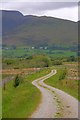
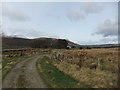
Track from Lobbs
With a fine view of Sharp Edge (Image).
Image: © Mick Garratt
Taken: 27 May 2011
0.15 miles
6
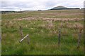
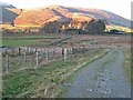
Broken Stile, near Highgateclose
In the distance is Great Mell fell (Image).
Image: © Mick Garratt
Taken: 27 May 2011
0.19 miles
7
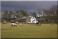
Highgate
Many times extended, it would seem!
Image: © Ian Capper
Taken: 11 Apr 2008
0.21 miles
8
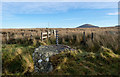
Iron fence post set into rock
The rock is beside the road leading to the farms at Highgateclose and Lobbs; it still supports fencing wires. The cone of Great Mell Fell rises in the distance beyond a good deal of moorland.
Image: © Trevor Littlewood
Taken: 17 Dec 2016
0.21 miles
9
Highgate
As far removed from its counterpart in London as one could imagine! The boulders in the foreground are one of a number of such groups in this field.
Image: © Ian Capper
Taken: 11 Apr 2008
0.22 miles