IMAGES TAKEN NEAR TO
Troutbeck, PENRITH, CA11 0ST
Introduction
This page details the photographs taken nearby to CA11 0ST by members of the Geograph project.
The Geograph project started in 2005 with the aim of publishing, organising and preserving representative images for every square kilometre of Great Britain, Ireland and the Isle of Man.

There are currently over 7.5m images from over14,400 individuals and you can help contribute to the project by visiting https://www.geograph.org.uk
Image Map
Images are licensed for reuse under creativecommons.org/licenses/by-sa/2.0
Notes
- Clicking on the map will re-center to the selected point.
- The higher the marker number, the further away the image location is from the centre of the postcode.
Image Listing (8 Images Found)
Images are licensed for reuse under creativecommons.org/licenses/by-sa/2.0
Image
Details
Distance
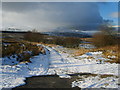
1
Disused railway at Gillsrow
The line of the old Cockermouth, Keswick and Penrith railway. Also followed here by an impromptu stream.
Image: © Oliver Dixon
Taken: 10 Dec 2007
0.18 miles
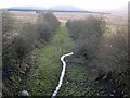
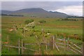
2
Route of an old railway
The hill in the distance is Great Dodd.
Image: © David Purchase
Taken: 29 Jul 2013
0.19 miles
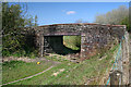
4
Old Railway Bridge
Near Gillsrow on the dismantled Keswick line. Disused for trains but still used by cars.
Image: © Michael Graham
Taken: 7 Feb 2009
0.20 miles
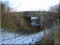
5
Cockermouth, Keswick & Penrith Railway
Bridge of the dismantled Cockermouth, Keswick and Penrith Railway near Gillsrow.
Image: © Peter McDermott
Taken: 18 Apr 2009
0.20 miles
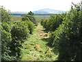
6
Course of Dismantled Railway
The Cockermouth, Keswick & Penrith Railway.
Image: © Mick Garratt
Taken: 27 May 2011
0.21 miles
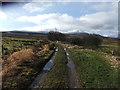
7
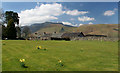
Redsike Cottages
View of Redsike Cottages with Blencathra in the background.
Image: © Peter McDermott
Taken: 18 Apr 2009
0.22 miles