IMAGES TAKEN NEAR TO
Penruddock, PENRITH, CA11 0SB
Introduction
This page details the photographs taken nearby to CA11 0SB by members of the Geograph project.
The Geograph project started in 2005 with the aim of publishing, organising and preserving representative images for every square kilometre of Great Britain, Ireland and the Isle of Man.

There are currently over 7.5m images from over14,400 individuals and you can help contribute to the project by visiting https://www.geograph.org.uk
Image Map
Images are licensed for reuse under creativecommons.org/licenses/by-sa/2.0
Notes
- Clicking on the map will re-center to the selected point.
- The higher the marker number, the further away the image location is from the centre of the postcode.
Image Listing (22 Images Found)
Images are licensed for reuse under creativecommons.org/licenses/by-sa/2.0
Image
Details
Distance
1
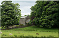
Farmhouse at Brownrigg
Brownrigg Farm lies between Great and Little Mell Fells.
The view is across a field from the access road.
Image: © Trevor Littlewood
Taken: 30 Jun 2016
0.03 miles
2
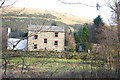
Brownriggs Farm
Nestles between the two Mell Fells
Image: © Bob Jenkins
Taken: 3 Jan 2006
0.04 miles
3
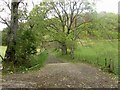
Track to Great Mell Fell
Looking along the track which provides access to the foot of Great Mell Fell from its junction with the country road near Brownrigg Farm.
Image: © Graham Robson
Taken: 7 Nov 2013
0.08 miles
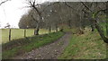
4
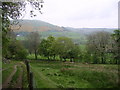
Track, Great Mell Fell
Looking towards Little Mell Fell
Image: © Michael Graham
Taken: 17 May 2008
0.09 miles
5
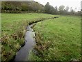
Mellfell Beck near Brownrigg Farm
Mellfell Beck as it flows through grassland close to Brownrigg Farm.
Image: © Graham Robson
Taken: 7 Nov 2013
0.09 miles
8
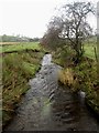
Looking south along Thackthwaite Beck
Looking south, or downstream, along Thackthwaite Beck from a footbridge over the stream.
Image: © Graham Robson
Taken: 7 Nov 2013
0.11 miles
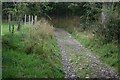
9
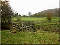
Footbridge over Thackthwaite Beck
The footbridge over Thackthwaite Beck which carries a public footpath across the stream. The path connects Brownrigg Farm and Greenrow.
Image: © Graham Robson
Taken: 7 Nov 2013
0.11 miles
10
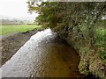
Looking north along Thackthwaite Beck
Looking north, or downstream, along Thackthwaite Beck close to Brownrigg Farm.
Image: © Graham Robson
Taken: 7 Nov 2013
0.11 miles