IMAGES TAKEN NEAR TO
Barraclough Fold, PENRITH, CA11 0QJ
Introduction
This page details the photographs taken nearby to Barraclough Fold, CA11 0QJ by members of the Geograph project.
The Geograph project started in 2005 with the aim of publishing, organising and preserving representative images for every square kilometre of Great Britain, Ireland and the Isle of Man.

There are currently over 7.5m images from over14,400 individuals and you can help contribute to the project by visiting https://www.geograph.org.uk
Image Map
Images are licensed for reuse under creativecommons.org/licenses/by-sa/2.0
Notes
- Clicking on the map will re-center to the selected point.
- The higher the marker number, the further away the image location is from the centre of the postcode.
Image Listing (122 Images Found)
Images are licensed for reuse under creativecommons.org/licenses/by-sa/2.0
Image
Details
Distance
1
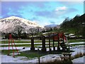
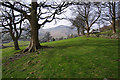
Playground, Glenridding
With Birkhouse Moor as a backdrop.
Image: © Mick Garratt
Taken: 18 Mar 2006
0.03 miles
2
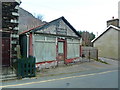
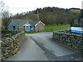
The Stores, Greenside Road, Glenridding
Image: © Alexander P Kapp
Taken: 21 Mar 2012
0.05 miles
3
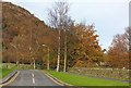
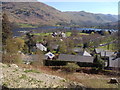
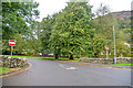
Barraclough Fold
Residential street in Glenridding.
Image: © Wayland Smith
Taken: 21 Nov 2015
0.06 miles
4
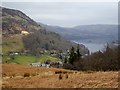
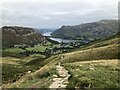
Glenridding and Ullswater
Seen from the col near Lanty's Tarn.
Image: © Oliver Dixon
Taken: 15 Mar 2015
0.06 miles
5
View to Glenridding and Ullswater
View from the eastern slope of Birkhouse Moor.
Image: © David Robinson
Taken: 20 Sep 2022
0.06 miles
7
Field at Glenridding
Birkhouse Moor is in the distance.
Image: © Ian Taylor
Taken: 30 Mar 2014
0.07 miles
9
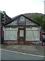
The Stores
In Glenridding former shop.
Image: © Michael Graham
Taken: 27 Jul 2010
0.07 miles
10
Glenridding : Greenside Road
Looking along Greenside Road off the A592.
Image: © Lewis Clarke
Taken: 25 Sep 2019
0.08 miles