IMAGES TAKEN NEAR TO
Hartsop, PENRITH, CA11 0NZ
Introduction
This page details the photographs taken nearby to CA11 0NZ by members of the Geograph project.
The Geograph project started in 2005 with the aim of publishing, organising and preserving representative images for every square kilometre of Great Britain, Ireland and the Isle of Man.

There are currently over 7.5m images from over14,400 individuals and you can help contribute to the project by visiting https://www.geograph.org.uk
Image Map
Images are licensed for reuse under creativecommons.org/licenses/by-sa/2.0
Notes
- Clicking on the map will re-center to the selected point.
- The higher the marker number, the further away the image location is from the centre of the postcode.
Image Listing (72 Images Found)
Images are licensed for reuse under creativecommons.org/licenses/by-sa/2.0
Image
Details
Distance
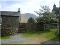
1
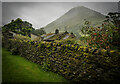
Village Outskirts, Hartsop
Truly stunning Village, the walls, the buildings and the view.
Image: © Brian Deegan
Taken: 12 Aug 2024
0.02 miles
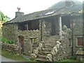
2
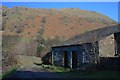
Out Buildings, Hartsop
Brock Crags behind.
Image: © Mick Garratt
Taken: 15 Feb 2008
0.02 miles
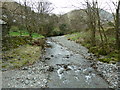
4
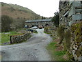
Hartsop Ford
This ford is found on the bridleway below Hartsop.
Image: © Ann Walton
Taken: 17 Sep 2017
0.04 miles
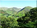
5
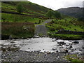
In Hartsop
From the track to Brothers Water looking towards Gray Crag
Image: © Michael Graham
Taken: 28 Apr 2010
0.05 miles
6
In Low Wood
Looking towards Hartsop Dodd from the wood
Image: © Michael Graham
Taken: 29 Aug 2010
0.06 miles
7
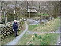
Path approaching Pasture Beck, Hartsop
Image: © Alexander P Kapp
Taken: 21 Mar 2012
0.07 miles
9
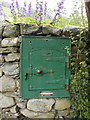
Outdoor Oven in Hartsop
Strangely placed oven door in farmhouse stone wall in Hartsop
Image: © John Charlton
Taken: 2 Aug 2002
0.08 miles
10
Hartsop
Hartsop is an off the beaten track hamlet of traditional Cumbrian houses
Image: © Carl Bendelow
Taken: 6 Oct 2002
0.08 miles