IMAGES TAKEN NEAR TO
Patterdale, PENRITH, CA11 0NL
Introduction
This page details the photographs taken nearby to CA11 0NL by members of the Geograph project.
The Geograph project started in 2005 with the aim of publishing, organising and preserving representative images for every square kilometre of Great Britain, Ireland and the Isle of Man.

There are currently over 7.5m images from over14,400 individuals and you can help contribute to the project by visiting https://www.geograph.org.uk
Image Map
Images are licensed for reuse under creativecommons.org/licenses/by-sa/2.0
Notes
- Clicking on the map will re-center to the selected point.
- The higher the marker number, the further away the image location is from the centre of the postcode.
Image Listing (140 Images Found)
Images are licensed for reuse under creativecommons.org/licenses/by-sa/2.0
Image
Details
Distance
3
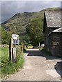
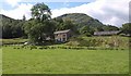
Track to Side Farm
The track, seen here from close to its junction with the A591, forms part of the walking circuit around Ullswater, followed as it is across the Goldrill Beck by footpath 357035. Beyond are the slopes of Patterdale Common below Place Fell.
Image: © Derek Harper
Taken: 21 Aug 2010
0.02 miles
4
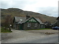
Patterdale Primary School
The small primary school in the valley of Patterdale.
Image: © Graham Robson
Taken: 23 Oct 2016
0.02 miles
5

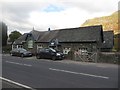
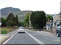
Patterdale School
Main road in Patterdale, Cumbria.
Image: © Wayland Smith
Taken: 21 Nov 2015
0.02 miles
7
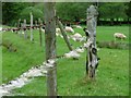
Fence, Side Farm
Protecting the sheep from straying into the river.
Image: © Mick Garratt
Taken: 20 May 2006
0.05 miles
8
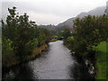
Goldrill Beck, Patterdale
From the footpath between Patterdale and Side Farm.
Image: © Dave Dunford
Taken: 18 Oct 2006
0.05 miles
9

Patterdale Churchyard
Daffodils in Patterdale churchyard with Place Fell in the background.
Image: © Philip Halling
Taken: 7 Apr 2009
0.05 miles
10
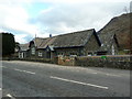
Buildings near Patterdale
Accommodation between Patterdale and Glenridding, seen from the A591, with Glebe House on the right.
Image: © Derek Harper
Taken: 21 Aug 2010
0.06 miles