IMAGES TAKEN NEAR TO
Thackthwaite, PENRITH, CA11 0NA
Introduction
This page details the photographs taken nearby to CA11 0NA by members of the Geograph project.
The Geograph project started in 2005 with the aim of publishing, organising and preserving representative images for every square kilometre of Great Britain, Ireland and the Isle of Man.

There are currently over 7.5m images from over14,400 individuals and you can help contribute to the project by visiting https://www.geograph.org.uk
Image Map
Images are licensed for reuse under creativecommons.org/licenses/by-sa/2.0
Notes
- Clicking on the map will re-center to the selected point.
- The higher the marker number, the further away the image location is from the centre of the postcode.
Image Listing (7 Images Found)
Images are licensed for reuse under creativecommons.org/licenses/by-sa/2.0
Image
Details
Distance
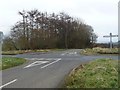
1
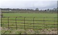
Tree nursery at Lanehead
Looking west from the crossroads.
Image: © Christine Johnstone
Taken: 10 Mar 2017
0.12 miles
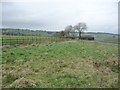
2
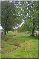
Stream Between Two Fences
Near Sparket.
Image: © Mick Garratt
Taken: 6 Sep 2011
0.18 miles
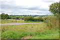
3
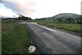
Wide Junction, Narrow Roads at Sparket
The narrow roads have sufficiently wide verges at the crossroads to be apparent on the 1:25000 OS map.
Image: © Bob Jenkins
Taken: 4 Jan 2006
0.22 miles
5
Left for Penruddock, right for Bennethead
Looking eastwards to the crossroads at Lanehead. A 238 metre spot height.
Image: © Christine Johnstone
Taken: 10 Mar 2017
0.22 miles
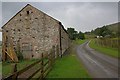
6
The north side of the crossroads at Lanehead
A great square of land is railed off around the road junction. This road goes to Sparket Mill and the A66.
Image: © Christine Johnstone
Taken: 10 Mar 2017
0.23 miles
7
Road to Sparket Mill
Taken from the crossroads between Dacre and Thackthwaite.
Image: © Trevor Harris
Taken: 28 Aug 2013
0.23 miles