IMAGES TAKEN NEAR TO
Dacre, PENRITH, CA11 0LU
Introduction
This page details the photographs taken nearby to CA11 0LU by members of the Geograph project.
The Geograph project started in 2005 with the aim of publishing, organising and preserving representative images for every square kilometre of Great Britain, Ireland and the Isle of Man.

There are currently over 7.5m images from over14,400 individuals and you can help contribute to the project by visiting https://www.geograph.org.uk
Image Map
Images are licensed for reuse under creativecommons.org/licenses/by-sa/2.0
Notes
- Clicking on the map will re-center to the selected point.
- The higher the marker number, the further away the image location is from the centre of the postcode.
Image Listing (11 Images Found)
Images are licensed for reuse under creativecommons.org/licenses/by-sa/2.0
Image
Details
Distance
1
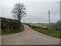
Public footpath to Sparket Mill and Hutton
Also the vehicle entrance to Southwaite Farm.
Image: © Christine Johnstone
Taken: 10 Mar 2017
0.03 miles
2
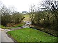
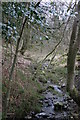
Ford on a farm track south of Southwaite Farm
Created by Southwaite Beck, a tributary of Dacre Beck.
Image: © Christine Johnstone
Taken: 10 Mar 2017
0.05 miles
3
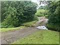
Ford at Southwaite Farm
This ford on Southwaite Gill is found opposite the entrance to Southwaite Farm near Dacre.
Image: © John Walton
Taken: 25 Jun 2019
0.05 miles
4
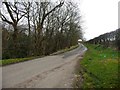
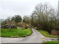
The road from Dacre to Lanehead and Nabend
Heading westwards by the entrance to Southwaite Farm.
Image: © Christine Johnstone
Taken: 10 Mar 2017
0.05 miles
5
Ford on the road near Southwaite Farm
Dry at the moment. Where Southwaite Beck crosses the road from Nabend and Lanehead to Dacre.
Image: © Christine Johnstone
Taken: 10 Mar 2017
0.05 miles
6
Snowdrops on the north bank of Southwaite Beck
Near Southwaite Farm. Early March.
Image: © Christine Johnstone
Taken: 10 Mar 2017
0.06 miles
8
![Way into the wood [no public access]](https://s0.geograph.org.uk/geophotos/05/31/37/5313784_283fb781_120x120.jpg)
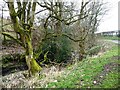
Way into the wood [no public access]
The wood is alongside a tributary of Dacre Beck, on the north side of the road from Dacre.
Image: © Christine Johnstone
Taken: 10 Mar 2017
0.17 miles
9
The road to Occupation Wood and Soulby Fell Farm
This no-through-road is classed as an 'other route with public access'.
Image: © Christine Johnstone
Taken: 10 Mar 2017
0.18 miles
10
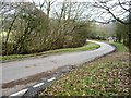
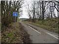
The road to Dacre
Dropping down to High Bridge [out of sight, round the bend].
Image: © Christine Johnstone
Taken: 10 Mar 2017
0.21 miles