IMAGES TAKEN NEAR TO
Watermillock, PENRITH, CA11 0LS
Introduction
This page details the photographs taken nearby to CA11 0LS by members of the Geograph project.
The Geograph project started in 2005 with the aim of publishing, organising and preserving representative images for every square kilometre of Great Britain, Ireland and the Isle of Man.

There are currently over 7.5m images from over14,400 individuals and you can help contribute to the project by visiting https://www.geograph.org.uk
Image Map
Images are licensed for reuse under creativecommons.org/licenses/by-sa/2.0
Notes
- Clicking on the map will re-center to the selected point.
- The higher the marker number, the further away the image location is from the centre of the postcode.
Image Listing (16 Images Found)
Images are licensed for reuse under creativecommons.org/licenses/by-sa/2.0
Image
Details
Distance
1
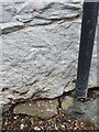
Ordnance Survey Bench Mark
This mark is located on a building at Cove Caravan site. These marks were used by Ordnance Survey for mapping purposes.
Image
Image: © V1ncenze
Taken: 9 May 2021
0.02 miles
2
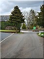
Cove caravan Site
Main road that runs through the Cove Caravan site. The building on the left has an Ordnance Survey bench mark.
Image
Image: © V1ncenze
Taken: 9 May 2021
0.02 miles
3
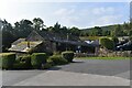
The Quiet Site Caravan Park
The shop and reception at The Quiet Site, converted from old farm buildings.
Image: © Robert Struthers
Taken: 5 Sep 2021
0.03 miles
4
The Quiet Site
A caravan park beneath Little Mell Fell.
Image: © Robert Struthers
Taken: 8 Sep 2021
0.05 miles
5
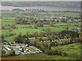
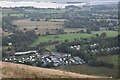
Cove Park seen from Little Mell Fell summit
Looking down on Cove Park caravan park and camp site from the summit of Little Mell Fell. Part of Ullswater can be seen in the background.
Image: © Graham Robson
Taken: 7 Nov 2013
0.07 miles
6
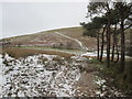
Little Mell Fell
Photo taken on one of the coldest days of 2017 and not a soul in sight in this view.
Image: © Peter S
Taken: 30 Dec 2017
0.11 miles
8
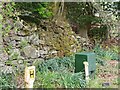
Boundary Wall, Watermillock
Old boundary wall located near Watermillock, Cumbria. The wall also has an Ordnance Survey bench mark.
Image
Image: © V1ncenze
Taken: 9 May 2021
0.15 miles
9
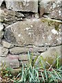
Ordnance Survey Bench Mark
This mark is located on a boundary wall near to Watermillock, Cumbria. These marks were used by Ordnance Survey for mapping purposes.
Image
Image: © V1ncenze
Taken: 9 May 2021
0.15 miles
10
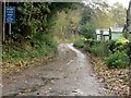
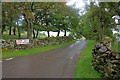
Single track road with passing places
The sign says it all. Cove Park caravan site is on the other side of the wall on the right hand side of the road.
Image: © Graham Robson
Taken: 7 Nov 2013
0.16 miles