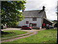
IMAGES TAKEN NEAR TO
Dacre, PENRITH, CA11 0HN
Introduction
This page details the photographs taken nearby to CA11 0HN by members of the Geograph project.
The Geograph project started in 2005 with the aim of publishing, organising and preserving representative images for every square kilometre of Great Britain, Ireland and the Isle of Man.

There are currently over 7.5m images from over14,400 individuals and you can help contribute to the project by visiting https://www.geograph.org.uk
Image Map
Images are licensed for reuse under creativecommons.org/licenses/by-sa/2.0
Notes
- Clicking on the map will re-center to the selected point.
- The higher the marker number, the further away the image location is from the centre of the postcode.
Image Listing (8 Images Found)
Images are licensed for reuse under creativecommons.org/licenses/by-sa/2.0
Image
Details
Distance
1
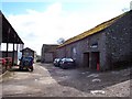
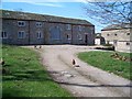
Aldby Farm.
The sign and cars indicates non agriculture use of the buildings as is often the case around this area as the farmers have diversified to supplement income.
Image: © John Holmes
Taken: 4 Apr 2006
0.05 miles
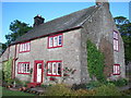
3
Aldby Farm Buildings
Building converted from farming use to offices and small industrial units in 1980s.
Image: © John Douglas
Taken: 10 Aug 2002
0.05 miles
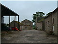
5
Aldby Farm Yard
Buildings converted from farming use to offices and small industrial units in 1980s. Stable building on right of image dates from 1697.
Image: © John Douglas
Taken: 24 Apr 2005
0.05 miles
7
Hall Bank, from the west
Steeper on the south side than the north. The summit is about 290 metres above sea level.
Image: © Christine Johnstone
Taken: 10 Mar 2017
0.22 miles
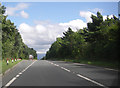
8
Westbound A66
The direction sign at the side is "patched". Its background colour is green; the black lettering on a white patch indicates that the landfill site is on a minor road.
Image: © David Dixon
Taken: 15 Feb 2013
0.23 miles