IMAGES TAKEN NEAR TO
Dacre, PENRITH, CA11 0HJ
Introduction
This page details the photographs taken nearby to CA11 0HJ by members of the Geograph project.
The Geograph project started in 2005 with the aim of publishing, organising and preserving representative images for every square kilometre of Great Britain, Ireland and the Isle of Man.

There are currently over 7.5m images from over14,400 individuals and you can help contribute to the project by visiting https://www.geograph.org.uk
Image Map
Images are licensed for reuse under creativecommons.org/licenses/by-sa/2.0
Notes
- Clicking on the map will re-center to the selected point.
- The higher the marker number, the further away the image location is from the centre of the postcode.
Image Listing (65 Images Found)
Images are licensed for reuse under creativecommons.org/licenses/by-sa/2.0
Image
Details
Distance
2
Dacre: The road leading up to St. Andrew's Church
Image: © Michael Garlick
Taken: 3 Aug 2019
0.00 miles

5
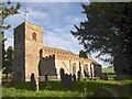
St Andrew's Church, Dacre
Originally 12C, thought to be built on the site of a monastery. The arcades are 13C as are the aisles, although in Perpendicular style with battlements. The west tower is Norman, but was rebuilt in 1810, retaining the plain arch into the nave. The chancel is late 12C, with a doorway with thin shafts, and long round-arched windows. The chancel arch, vestry and east windows are 19C, with stained glass by Clayton & Bell. There are two parts of cross-shafts in the church, an Anglian one (9C) with naturalistic detail and a human-faced quadruped, and a Viking one of the 10C. The four corners of the original churchyard are marked by four bears (see photo of churchyard).
Image: © Humphrey Bolton
Taken: 29 Oct 2006
0.02 miles
6
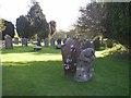
Dacre churchyard
The four corners of the original churchyard (smaller than the present one) are marked by four medieval stone bears. They were studied by Chancellor Furguson in 1890, and he believed that they depict a legendary tale, which can be summarised by: bear sleeping, bear attacked by wild cat, bear shakes off cat, bear eats cat. The bear in this photo is the second in the sequence, but the cat has been worn away and we just see the bear looking over its shoulder.
Image: © Humphrey Bolton
Taken: 29 Oct 2006
0.02 miles
7
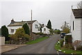
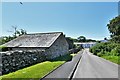
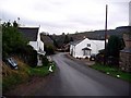
Dacre village street
This attractive village is on a south-facing slope above Dacre Beck.
Image: © Jim Barton
Taken: 12 Oct 2011
0.03 miles
8
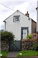
The School House, Dacre
The inscription above the door reads:"Dacre School Builded 1749"
See Image for its appearance in 2006.
Image: © Trevor Harris
Taken: 28 Aug 2013
0.03 miles
9
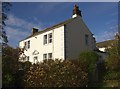
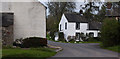
Rose Bank, Dacre village
This Grade II house is partly of 1689 and partly of 1773. The old part is at the rear, and is dated and inscribed over the side entrance "T & AW 1689". The inscription over the front doorway is: "T.H. 1773".
Image: © Humphrey Bolton
Taken: 29 Oct 2006
0.04 miles
10
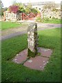
Stone on the green, Dacre village
Dacre has a tiny village green, and on it is this stone, fitted with ironwork. The caption of a photograph in the Cumbria magazine describes it as a gate stoop, but it looks to me like a very uncomfortable version of the stocks, with three curves in the iron bar to hold someone's wrists and/or ankles.
Image: © Humphrey Bolton
Taken: 29 Oct 2006
0.04 miles