IMAGES TAKEN NEAR TO
Slapestones, Stainton, PENRITH, CA11 0FL
Introduction
This page details the photographs taken nearby to CA11 0FL by members of the Geograph project.
The Geograph project started in 2005 with the aim of publishing, organising and preserving representative images for every square kilometre of Great Britain, Ireland and the Isle of Man.

There are currently over 7.5m images from over14,400 individuals and you can help contribute to the project by visiting https://www.geograph.org.uk
Image Map
Images are licensed for reuse under creativecommons.org/licenses/by-sa/2.0
Notes
- Clicking on the map will re-center to the selected point.
- The higher the marker number, the further away the image location is from the centre of the postcode.
Image Listing (4 Images Found)
Images are licensed for reuse under creativecommons.org/licenses/by-sa/2.0
Image
Details
Distance
1
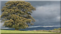
Lone tree near Penrith
Late afternoon sunshine on a lone tree near Penrith.
Image: © Colin Kinnear
Taken: 24 Sep 2018
0.11 miles
2
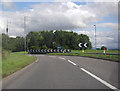
A66 Roundabout near Rheged Discovery Centre
Image: © Peter Bond
Taken: 20 Aug 2012
0.19 miles
3
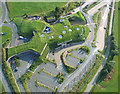
Rheged - 'The Village in The Hill'
Rheged is the largest grass covered building in Europe. Built in a disused limestone quarry and designed to resemble a lakeland hill to blend in with its surrounding environment.
http://www.visitcumbria.com/pen/rheged.htm
Image: © Simon Ledingham
Taken: 14 Aug 2004
0.20 miles
4
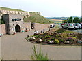
Rheged Centre
Not sure to class this as a shopping or leisure centre. Neither fits the bill.
Image: © Mick Garratt
Taken: 31 Aug 2005
0.24 miles