IMAGES TAKEN NEAR TO
Stainton, PENRITH, CA11 0ES
Introduction
This page details the photographs taken nearby to CA11 0ES by members of the Geograph project.
The Geograph project started in 2005 with the aim of publishing, organising and preserving representative images for every square kilometre of Great Britain, Ireland and the Isle of Man.

There are currently over 7.5m images from over14,400 individuals and you can help contribute to the project by visiting https://www.geograph.org.uk
Image Map
Images are licensed for reuse under creativecommons.org/licenses/by-sa/2.0
Notes
- Clicking on the map will re-center to the selected point.
- The higher the marker number, the further away the image location is from the centre of the postcode.
Image Listing (5 Images Found)
Images are licensed for reuse under creativecommons.org/licenses/by-sa/2.0
Image
Details
Distance
1
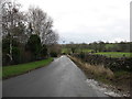
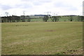
Houses in Stainton over field
Homes on the south side of Stainton seen over a field from a minor road south of the village.
Image: © Trevor Littlewood
Taken: 26 Nov 2021
0.15 miles
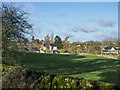
2
Houses across the green - 2
Terraced houses in Stainton seen across the village green.
Image: © Trevor Littlewood
Taken: 26 Nov 2021
0.18 miles
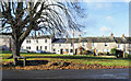
3
Houses across the green
Terraced houses in Stainton across the village Green.
Image: © Trevor Littlewood
Taken: 26 Nov 2021
0.19 miles
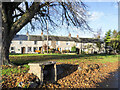
4
Grazing Land beside River Eamont
The river is by the trees, hidden from view.
Image: © Bob Jenkins
Taken: 28 Feb 2006
0.19 miles