IMAGES TAKEN NEAR TO
Stainton, PENRITH, CA11 0EB
Introduction
This page details the photographs taken nearby to CA11 0EB by members of the Geograph project.
The Geograph project started in 2005 with the aim of publishing, organising and preserving representative images for every square kilometre of Great Britain, Ireland and the Isle of Man.

There are currently over 7.5m images from over14,400 individuals and you can help contribute to the project by visiting https://www.geograph.org.uk
Image Map
Images are licensed for reuse under creativecommons.org/licenses/by-sa/2.0
Notes
- Clicking on the map will re-center to the selected point.
- The higher the marker number, the further away the image location is from the centre of the postcode.
Image Listing (20 Images Found)
Images are licensed for reuse under creativecommons.org/licenses/by-sa/2.0
Image
Details
Distance
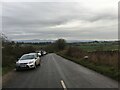
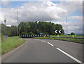
1
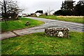
Junction of roads east of Stainton
A benchmark was cut on a gatepost on the far side of the minor road in 1855 as part of the Ordnance Survey levelling line from Penrith to Workington. The levelled height was 539.246 feet above Liverpool Datum. The surveyor's description was 'Mark on pier of gate at junction of road to Patterdale'.
Image: © Roger Templeman
Taken: 19 Feb 2020
0.04 miles
2
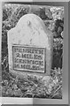
Old Milestone east of Keswick, Stainton parish
Keswick iron plate by the A66, in parish of Stainton (South Lakeland District), by the road.
Lost since 1940.
Inscription reads:-
PENRITH
2.MILES
KESWICK
16.MILES
Milestone Society National ID: CU_PRKW02
Image: © Milestone Society
Taken: Unknown
0.07 miles
4
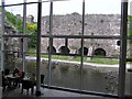
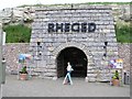
Rheged Visitor Centre looking out
From the dining centre, you can see the old lime kilns.
Image: © Kenneth Allen
Taken: 4 Jun 2006
0.11 miles
5
Rheged Visitor Centre
Built partly underground, it has a grass roof
Image: © Kenneth Allen
Taken: 4 Jun 2006
0.11 miles
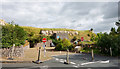
7
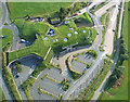
Rheged - 'The Village in The Hill'
Rheged is the largest grass covered building in Europe. Built in a disused limestone quarry and designed to resemble a lakeland hill to blend in with its surrounding environment.
http://www.visitcumbria.com/pen/rheged.htm
Image: © Simon Ledingham
Taken: 14 Aug 2004
0.16 miles
8
Wooden fort, the Rheged Centre
This looks like fun, but nobody was playing on this miserable day - think it was closed anyway.
Image: © Rose and Trev Clough
Taken: 17 Mar 2012
0.17 miles
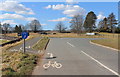
9
A66 Roundabout near Rheged Discovery Centre
Image: © Peter Bond
Taken: 20 Aug 2012
0.17 miles
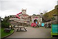
10
Rheged Centre - closed
The Rheged Centre might be thought of as an 'official', Lake District National Park Operation but in fact it's one part of a private business which also owns Tebay Services on the M6, Gloucester Services on the M5 and a hotel group.
At the time the image was recorded the centre was closed - impact of Covid19 outbreak - but a notice there tells of it reopening in Autumn 2020.
Image: © Trevor Littlewood
Taken: 4 Sep 2020
0.18 miles