IMAGES TAKEN NEAR TO
Redhills, PENRITH, CA11 0DQ
Introduction
This page details the photographs taken nearby to CA11 0DQ by members of the Geograph project.
The Geograph project started in 2005 with the aim of publishing, organising and preserving representative images for every square kilometre of Great Britain, Ireland and the Isle of Man.

There are currently over 7.5m images from over14,400 individuals and you can help contribute to the project by visiting https://www.geograph.org.uk
Image Map
Images are licensed for reuse under creativecommons.org/licenses/by-sa/2.0
Notes
- Clicking on the map will re-center to the selected point.
- The higher the marker number, the further away the image location is from the centre of the postcode.
Image Listing (31 Images Found)
Images are licensed for reuse under creativecommons.org/licenses/by-sa/2.0
Image
Details
Distance
1
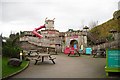
Wooden fort, the Rheged Centre
This looks like fun, but nobody was playing on this miserable day - think it was closed anyway.
Image: © Rose and Trev Clough
Taken: 17 Mar 2012
0.03 miles
2
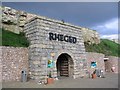
Rheged Discovery Centre, Penrith
Canolfan Ddarganfod Rheged, Penrith
Image: © Christopher R Ware
Taken: 2 Sep 2004
0.03 miles
3
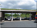
Services at Rheged off A66
With a grass roof
Image: © Alex McGregor
Taken: 22 Jun 2010
0.03 miles
4
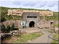
Rheged Centre - closed
The Rheged Centre might be thought of as an 'official', Lake District National Park Operation but in fact it's one part of a private business which also owns Tebay Services on the M6, Gloucester Services on the M5 and a hotel group.
At the time the image was recorded the centre was closed - impact of Covid19 outbreak - but a notice there tells of it reopening in Autumn 2020.
Image: © Trevor Littlewood
Taken: 4 Sep 2020
0.03 miles
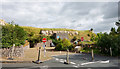
5
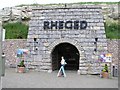
Rheged Discovery Centre
Rheged is described in poetic sources as one of the kingdoms of the Hen Ogledd ("Old North"), the Brittonic-speaking region of what is now Northern England and southern Scotland, in the Early Middle Ages. Some modern scholars have suggested that it included what is now Cumbria in North West England and possibly extended into Lancashire and Scotland (http://en.wikipedia.org/wiki/Rheged Wikipedia)
The name Rheged has been adopted by the Rheged Centre close to Penrith in Cumbria. The centre, which was opened in 2000, has a number of retail outlets and cafés with a Cumbrian theme, as well as the largest turf roof in Europe and a giant cinema screen.
Image: © David Dixon
Taken: 11 Apr 2014
0.04 miles
6
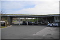
Petrol station at Rheged
This is part of the Rheged complex with the grass-covered roof. It is owned by the same people who own Tebay Services on the M6.
Image: © Bill Boaden
Taken: 24 Apr 2010
0.05 miles
7
Rheged Centre
Not sure to class this as a shopping or leisure centre. Neither fits the bill.
Image: © Mick Garratt
Taken: 31 Aug 2005
0.05 miles
8
Rheged Visitor Centre
Built partly underground, it has a grass roof
Image: © Kenneth Allen
Taken: 4 Jun 2006
0.06 miles
9
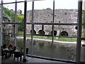
Rheged Visitor Centre looking out
From the dining centre, you can see the old lime kilns.
Image: © Kenneth Allen
Taken: 4 Jun 2006
0.06 miles
10
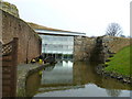
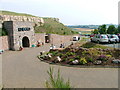
Rheged
Ornamental pond at the back of the centre.
Image: © Michael Graham
Taken: 23 Feb 2011
0.07 miles