IMAGES TAKEN NEAR TO
North Terrace, PENRITH, CA10 3XH
Introduction
This page details the photographs taken nearby to North Terrace, CA10 3XH by members of the Geograph project.
The Geograph project started in 2005 with the aim of publishing, organising and preserving representative images for every square kilometre of Great Britain, Ireland and the Isle of Man.

There are currently over 7.5m images from over14,400 individuals and you can help contribute to the project by visiting https://www.geograph.org.uk
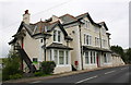
Image Map
Images are licensed for reuse under creativecommons.org/licenses/by-sa/2.0
Notes
- Clicking on the map will re-center to the selected point.
- The higher the marker number, the further away the image location is from the centre of the postcode.
Image Listing (29 Images Found)
Images are licensed for reuse under creativecommons.org/licenses/by-sa/2.0
Image
Details
Distance
1
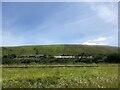
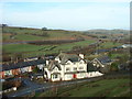
Cottages at Tebay
Roger Howe beyond the village
Image: © Eirian Evans
Taken: 9 Jul 2022
0.01 miles
2
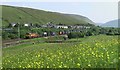
The coloured cottages of Tebay
A stray patch of sun on an otherwise dull day lights up the pastel coloured terraced houses near the old Junction Hotel Image
Image: © Karl and Ali
Taken: 2 Mar 2013
0.01 miles
3
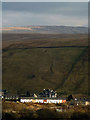
Railway cottages at Tebay
The bridge to the left carries the railway over the river Lune. From M6 southbound
Image: © John Firth
Taken: 13 May 2011
0.02 miles
4
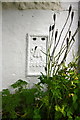
Benchmark on Lune Valley Court
Ordnance Survey flush bracket (serial number S6856) benchmark described on the Bench Mark Database at http://www.bench-marks.org.uk/bm12399
Image: © Roger Templeman
Taken: 11 Aug 2015
0.03 miles
5
Lune Valley Court beside A685
There is an OS benchmark Image under the stairs of the near corner of the hotel
Image: © Roger Templeman
Taken: 11 Aug 2015
0.03 miles
6
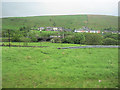
The old Junction Hotel Tebay
This private house used to be the Junction Hotel standing at the top of the road leading down to where Tebay station used to be. The West Coast main line (with Pendolino) and the M6 are in the background.
Image: © pete simpson
Taken: 13 Jan 2005
0.03 miles
8
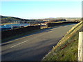
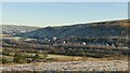
A685 and looking across the Lune Valley
Looking across the A685 road through Tebay, across the Lune Valley, with industrial units and the M6 motorway bridge over the River Lune in the background.
Image: © Jamie Allen
Taken: 26 Dec 2008
0.04 miles
9
Railway cottages, Tebay
A village created just for the railways. Here there was an engine shed providing banking locomotives for the climb up to Shap summit and it was also a junction for the now closed Stainmore line to Barnard Castle.
Image: © Don Burgess
Taken: 8 Jun 2006
0.04 miles
10
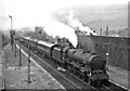
Down WCML express passing Tebay Station
View southward from the station footbridge, towards Lancaster, Preston and the South. Rebuilt 'Royal Scot' 7P 4-6-0 No. 46127 'The Old Contemptibles' on the 09.05 Crewe to Perth express is about to tackle the formidable Shap Bank (5½ miles, mostly at 1-in-75). Behind the wall on the Down side is the Locomotive Depot, which housed the banking engines needed for freight trains, if not for this express. The hills (1,250 - 1,350 ft.) behind and across the Lune Valley are Jeffrey's Mount and Grayrigg Common - and of course it's raining! Tebay station was closed on 1/7/68.
Image: © Ben Brooksbank
Taken: 7 Oct 1961
0.04 miles