IMAGES TAKEN NEAR TO
Gaisgill, PENRITH, CA10 3UW
Introduction
This page details the photographs taken nearby to CA10 3UW by members of the Geograph project.
The Geograph project started in 2005 with the aim of publishing, organising and preserving representative images for every square kilometre of Great Britain, Ireland and the Isle of Man.

There are currently over 7.5m images from over14,400 individuals and you can help contribute to the project by visiting https://www.geograph.org.uk
Image Map
Images are licensed for reuse under creativecommons.org/licenses/by-sa/2.0
Notes
- Clicking on the map will re-center to the selected point.
- The higher the marker number, the further away the image location is from the centre of the postcode.
Image Listing (20 Images Found)
Images are licensed for reuse under creativecommons.org/licenses/by-sa/2.0
Image
Details
Distance
1

Penned sheep at Ellergill
A mixture of ewes, mainly mules with at least one Rough Fell and even a Herdwick in there.
Image: © Karl and Ali
Taken: 24 Mar 2013
0.02 miles

6
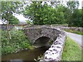
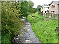
Bridge over Longdale Beck at Longdale
Image: © Raymond Knapman
Taken: 8 Jul 2010
0.14 miles
8
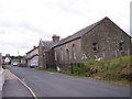
Wesleyan Chapel, Gaisgill
The stone above the door says Built AD 1841
Image: © Alexander P Kapp
Taken: 4 Oct 2005
0.18 miles
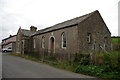
10
Gaisgill Reading Room
Dated 1909 the room looks derelict, but in good repair
Image: © Raymond Knapman
Taken: 8 Jul 2010
0.20 miles