IMAGES TAKEN NEAR TO
Tebay, PENRITH, CA10 3TG
Introduction
This page details the photographs taken nearby to CA10 3TG by members of the Geograph project.
The Geograph project started in 2005 with the aim of publishing, organising and preserving representative images for every square kilometre of Great Britain, Ireland and the Isle of Man.

There are currently over 7.5m images from over14,400 individuals and you can help contribute to the project by visiting https://www.geograph.org.uk
Image Map
Images are licensed for reuse under creativecommons.org/licenses/by-sa/2.0
Notes
- Clicking on the map will re-center to the selected point.
- The higher the marker number, the further away the image location is from the centre of the postcode.
Image Listing (4 Images Found)
Images are licensed for reuse under creativecommons.org/licenses/by-sa/2.0
Image
Details
Distance
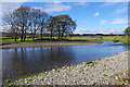
1
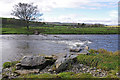
Ford across the River Lune
A public footpath is shown fording the river about here. This small weir appears to be the remains of the ford.
Image: © Ian Taylor
Taken: 24 Oct 2010
0.22 miles
2
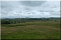
Across farmland from Pikestone Lane
Looking towards the valley with the railway and M6 motorway.
Image: © DS Pugh
Taken: 9 Jul 2020
0.22 miles
4
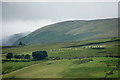
Sheep on Loups Fell, Tebay
Taken from Tebay services, with Jeffrey's Mount in the background.
Image: © Mike Pennington
Taken: 26 Jul 2010
0.23 miles