IMAGES TAKEN NEAR TO
Bretherdale, PENRITH, CA10 3TE
Introduction
This page details the photographs taken nearby to CA10 3TE by members of the Geograph project.
The Geograph project started in 2005 with the aim of publishing, organising and preserving representative images for every square kilometre of Great Britain, Ireland and the Isle of Man.

There are currently over 7.5m images from over14,400 individuals and you can help contribute to the project by visiting https://www.geograph.org.uk
Image Map
Images are licensed for reuse under creativecommons.org/licenses/by-sa/2.0
Notes
- Clicking on the map will re-center to the selected point.
- The higher the marker number, the further away the image location is from the centre of the postcode.
Image Listing (19 Images Found)
Images are licensed for reuse under creativecommons.org/licenses/by-sa/2.0
Image
Details
Distance
1
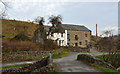
Houses at Midwath Stead
Midwath Stead is a small settlement in Bretherdale where there are several occupied houses; the view is along the valley road and across the bridge over Bretherdale Beck. The smaller of the two houses is named Midwath Cottage.
Image: © Trevor Littlewood
Taken: 25 Nov 2014
0.02 miles
2
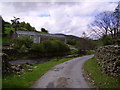
Midwath Stead
From the gated road through the Bretherdale.
Image: © Michael Graham
Taken: 12 May 2007
0.04 miles
3
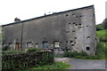
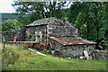
Farm building at Midwath Stead
There is an OS benchmark Image on the right hand corner of the building where the cement cladding has broken away
Image: © Roger Templeman
Taken: 11 Aug 2015
0.04 miles
4
Midwath Stead
Bretherdale, Westmorland. Much of Corkham Wood in the background has been felled.
Image: © Richard Webb
Taken: 25 Jul 2015
0.05 miles
5
Benchmark on barn at Midwath Stead
Ordnance Survey pivot benchmark described on the Bench Mark Database at http://www.bench-marks.org.uk/bm69623
Image: © Roger Templeman
Taken: 11 Aug 2015
0.05 miles
6
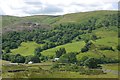
Midwath Stead
Barn above the hamlet of Midwath Stead in Bretherdale.
Image: © Peter McDermott
Taken: 9 Jul 2011
0.05 miles
7
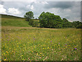
Meadow near Midwath Stead
Bright with wildflowers.
Image: © Karl and Ali
Taken: 7 Jul 2012
0.09 miles
8
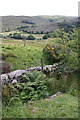
View from minor road NE of Midwath Stead
There is an OS benchmark Image on the rock in the foreground
Image: © Roger Templeman
Taken: 11 Aug 2015
0.14 miles
9
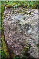
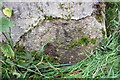
Benchmark on rock beside road NE of Midwath Stead
Ordnance Survey rivet benchmark described on the Bench Mark Database at http://www.bench-marks.org.uk/bm69621
Image: © Roger Templeman
Taken: 11 Aug 2015
0.14 miles
10
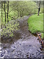
Bretherdale Beck
The swollen Beck as it passes under the bridge near Midwath Stead
Image: © Michael Graham
Taken: 12 May 2007
0.14 miles