IMAGES TAKEN NEAR TO
Tebay, PENRITH, CA10 3SZ
Introduction
This page details the photographs taken nearby to CA10 3SZ by members of the Geograph project.
The Geograph project started in 2005 with the aim of publishing, organising and preserving representative images for every square kilometre of Great Britain, Ireland and the Isle of Man.

There are currently over 7.5m images from over14,400 individuals and you can help contribute to the project by visiting https://www.geograph.org.uk
Image Map
Images are licensed for reuse under creativecommons.org/licenses/by-sa/2.0
Notes
- Clicking on the map will re-center to the selected point.
- The higher the marker number, the further away the image location is from the centre of the postcode.
Image Listing (26 Images Found)
Images are licensed for reuse under creativecommons.org/licenses/by-sa/2.0
Image
Details
Distance
1
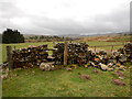
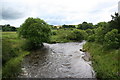
Stile on Coatflatt footpath
The stile seems quite substantial and robust, despite the adjacent wall being in a state of collapse - maybe undermined by those pesky moles ? The footpath itself is pretty faint on the ground but sticks to the flat grassy grazing land on the floodplain of Chapel Beck which flows on the left past the clump of conifers, on its way to meet the River Lune just before Tebay Bridge.
Image: © Andy Waddington
Taken: 5 Apr 2022
0.07 miles
2
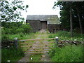
Barn west of Coatflatt Hall, off the B6260
Image: © Alexander P Kapp
Taken: 17 Jul 2008
0.15 miles

4
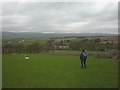
Footpath above Coatflatt Hall
Descending through sheep pastures. Beyond is the M6 motorway with the eastern foothills of the Lake District rising on the skyline.
Image: © Karl and Ali
Taken: 10 May 2015
0.17 miles
5
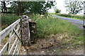
Gateway beside B6260 west of Coatflatt Hall
There is an OS benchmark Image on the stone gatepost
Image: © Roger Templeman
Taken: 11 Aug 2015
0.17 miles
6
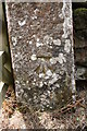
Benchmark on gatepost beside B6260
Ordnance Survey cut mark benchmark described on the Bench Mark Database at http://www.bench-marks.org.uk/bm69770
Image: © Roger Templeman
Taken: 11 Aug 2015
0.17 miles
7
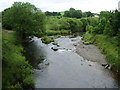
Confluence of the River Lune and Chapel Beck
Image: © Alexander P Kapp
Taken: 17 Jul 2008
0.18 miles
8
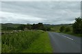
Between Orton and Tebay
Looking along the B6260.
Image: © DS Pugh
Taken: 9 Jul 2020
0.18 miles
9
"Confluence"
The confluence of Chapel Beck and the River Lune taken from Tebay Bridge.
Image: © David Ashcroft
Taken: 18 Jul 2009
0.18 miles
