IMAGES TAKEN NEAR TO
Orton, PENRITH, CA10 3SJ
Introduction
This page details the photographs taken nearby to CA10 3SJ by members of the Geograph project.
The Geograph project started in 2005 with the aim of publishing, organising and preserving representative images for every square kilometre of Great Britain, Ireland and the Isle of Man.

There are currently over 7.5m images from over14,400 individuals and you can help contribute to the project by visiting https://www.geograph.org.uk
Image Map
Images are licensed for reuse under creativecommons.org/licenses/by-sa/2.0
Notes
- Clicking on the map will re-center to the selected point.
- The higher the marker number, the further away the image location is from the centre of the postcode.
Image Listing (5 Images Found)
Images are licensed for reuse under creativecommons.org/licenses/by-sa/2.0
Image
Details
Distance
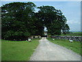
1
Lime Kiln near Blasterfield Farm
Lime Kiln just off the Orton - Appleby Road near Blasterfield Farm.
Image: © mauldy
Taken: 2 Jul 2006
0.09 miles
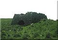
2

The valley of Raven's Gill
The North Pennines in the distance.
Image: © Karl and Ali
Taken: 8 May 2011
0.22 miles
3
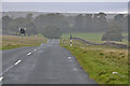
The B6260 heading south
With drizzle beginning to cover all.
Image: © Nigel Brown
Taken: 13 Oct 2016
0.23 miles
4
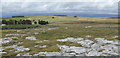
View towards Blasterfield Farm
Limestone pavement in the foreground and the north Pennine scarp in the far distance.
Image: © Jonathan Billinger
Taken: 31 Aug 2007
0.24 miles