IMAGES TAKEN NEAR TO
Shap, PENRITH, CA10 3RA
Introduction
This page details the photographs taken nearby to CA10 3RA by members of the Geograph project.
The Geograph project started in 2005 with the aim of publishing, organising and preserving representative images for every square kilometre of Great Britain, Ireland and the Isle of Man.

There are currently over 7.5m images from over14,400 individuals and you can help contribute to the project by visiting https://www.geograph.org.uk
Image Map
Images are licensed for reuse under creativecommons.org/licenses/by-sa/2.0
Notes
- Clicking on the map will re-center to the selected point.
- The higher the marker number, the further away the image location is from the centre of the postcode.
Image Listing (13 Images Found)
Images are licensed for reuse under creativecommons.org/licenses/by-sa/2.0
Image
Details
Distance
1
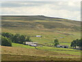
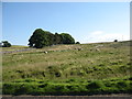
Hause Farm
With the M6 and a power line.
Image: © Richard Webb
Taken: 18 Jul 2021
0.02 miles
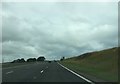
2
Hause Farm with M6 in the background.
A very high farm right next to the motorway, not quite the peace and quiet of years ago.
Image: © John Holmes
Taken: 17 Dec 2005
0.03 miles
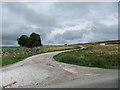
8
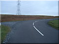
Junction of B6261 and track up to Shap Summit
Image: © David Marten
Taken: 15 Jan 2007
0.22 miles
9
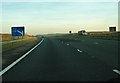
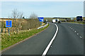
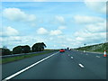
M6 motorway, northbound
This is 1/3 mile south of junction 39 on the M6 motorway. Although now clear, the warning lights still say "Fog".
Image: © Ann Cook
Taken: 12 Sep 2009
0.22 miles