IMAGES TAKEN NEAR TO
Shap, PENRITH, CA10 3QZ
Introduction
This page details the photographs taken nearby to CA10 3QZ by members of the Geograph project.
The Geograph project started in 2005 with the aim of publishing, organising and preserving representative images for every square kilometre of Great Britain, Ireland and the Isle of Man.

There are currently over 7.5m images from over14,400 individuals and you can help contribute to the project by visiting https://www.geograph.org.uk
Image Map
Images are licensed for reuse under creativecommons.org/licenses/by-sa/2.0
Notes
- Clicking on the map will re-center to the selected point.
- The higher the marker number, the further away the image location is from the centre of the postcode.
Image Listing (28 Images Found)
Images are licensed for reuse under creativecommons.org/licenses/by-sa/2.0
Image
Details
Distance
2
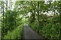
Road near Scout Green
Looking along the road just to the south of Scout Green.
Image: © DS Pugh
Taken: 9 Jul 2020
0.02 miles
3
Scout Green
View overlooking Scout Green.
Image: © Peter McDermott
Taken: 9 Jul 2011
0.03 miles
4
Middle Scout Green footbridge
Tucked away down a short path of closely mown grass, the footbridge takes on across Birk Beck and on to the footpath to Ewelock which makes its rather poorly defined way over some very boggy pasture up the hillside and past Buskethowe. Having started life as Wasdale Beck in a very rocky course, Birk Beck has changed character as well as name and is now slow flowing with little gradient on its way to form the first major tributary of the River Lune, at Tebay.
Image: © Andy Waddington
Taken: 11 Oct 2020
0.03 miles
5
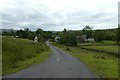
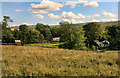
Scout Green
Looking through the village of Scout Green situated to the west of the railway and M6.
Image: © DS Pugh
Taken: 9 Jul 2020
0.06 miles
6
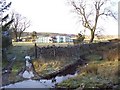
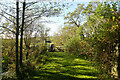
Farmers ford.
The modern traffic does not use the ford anymore with the exception of the farm traffic.
Image: © John Holmes
Taken: 17 Dec 2005
0.09 miles
7
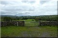
Gate near Scout Green
Looking from the road into a field to the east of Scout Green.
Image: © DS Pugh
Taken: 9 Jul 2020
0.09 miles
8
Large boulder at Scout Green
There should be an Ordnance Survey rivet benchmark on the boulder but it was not found
Image: © Roger Templeman
Taken: 11 Aug 2015
0.12 miles
9
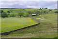
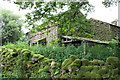
Farmland, Scout Green
With a field barn and wild flower meadows. The dry stone wall marks the boundary of the CRoW access land.
Image: © Ian Taylor
Taken: 11 Jun 2022
0.13 miles
10
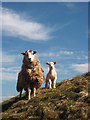
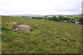
Ewe and lamb near Scout Green
A mule ewe guards her lamb attentively and watches to see if I have any bales of silage secreted about my person. It has been a long, cold winter and the grass is only just now starting to show hints of green growth.
Image: © Karl and Ali
Taken: 20 Apr 2013
0.15 miles