IMAGES TAKEN NEAR TO
Shap, PENRITH, CA10 3QY
Introduction
This page details the photographs taken nearby to CA10 3QY by members of the Geograph project.
The Geograph project started in 2005 with the aim of publishing, organising and preserving representative images for every square kilometre of Great Britain, Ireland and the Isle of Man.

There are currently over 7.5m images from over14,400 individuals and you can help contribute to the project by visiting https://www.geograph.org.uk
Image Map
Images are licensed for reuse under creativecommons.org/licenses/by-sa/2.0
Notes
- Clicking on the map will re-center to the selected point.
- The higher the marker number, the further away the image location is from the centre of the postcode.
Image Listing (6 Images Found)
Images are licensed for reuse under creativecommons.org/licenses/by-sa/2.0
Image
Details
Distance
1
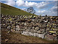
Varied geology in a drystone wall
In this short stretch of wall can be found stones of pink Shap granite, local Silurian siltstone, a kind of reddish sandstone and limestone (the big block at ground level). Some were probably moved here by past glaciers.
Image: © Karl and Ali
Taken: 20 Apr 2013
0.19 miles
2
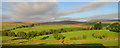
Birk Beck
View looking across Birk Beck seen from the WCML.
Image: © Peter McDermott
Taken: 2 Jun 2016
0.21 miles
4
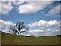
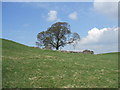
Tree and ruin at Castlehowe
The ruin is on private land with no nearby gate to allow a closer inspection. It could simply be a ruined barn despite the grandiose name.
Image: © Karl and Ali
Taken: 20 Apr 2013
0.23 miles
5
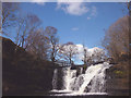
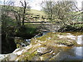
Docker Force, Birk Beck
The beck is a substantial stream, gathering water from a wide area. The water falls about 4m into a large pool which might make a good swimming hole in warm weather.
Image: © Karl and Ali
Taken: 20 Apr 2013
0.23 miles