IMAGES TAKEN NEAR TO
Shap, PENRITH, CA10 3ND
Introduction
This page details the photographs taken nearby to CA10 3ND by members of the Geograph project.
The Geograph project started in 2005 with the aim of publishing, organising and preserving representative images for every square kilometre of Great Britain, Ireland and the Isle of Man.

There are currently over 7.5m images from over14,400 individuals and you can help contribute to the project by visiting https://www.geograph.org.uk
Image Map
Images are licensed for reuse under creativecommons.org/licenses/by-sa/2.0
Notes
- Clicking on the map will re-center to the selected point.
- The higher the marker number, the further away the image location is from the centre of the postcode.
Image Listing (6 Images Found)
Images are licensed for reuse under creativecommons.org/licenses/by-sa/2.0
Image
Details
Distance
1
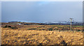
Rough grassland near to Rayside
The buildings at Rayside lie just beyond the minor ridge being crossed by the pair of hill walkers heading for the valley of Swindale. The snow-covered mountains in the distance are of the Far Eastern Fells of the Lake District.
Image: © Trevor Littlewood
Taken: 13 Dec 2014
0.17 miles
3
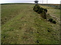
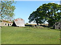
Earthworks
Extensive earthworks to the west of the river Lowther, are associated with the Shap Abbey Estate. This view is taken from where the Coast to Coast Path crosses the earthwork looking in a south west direction
Image: © Nigel Homer
Taken: 11 Feb 2006
0.21 miles
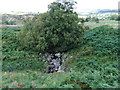
4
Air Valve, Near Tailbert Gill
With the access road built by the Manchester Water Engineers across the bottom of the photo. The valve presumably vents air from the pipeline carrying water to the people of Manchester.
Image: © Mick Garratt
Taken: 10 Mar 2009
0.21 miles
5
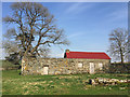
Agricultural building near Rayside
It appears to have been a dwelling at some time.
Image: © John Allan
Taken: 21 Apr 2018
0.24 miles
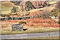
6
Falling Barn on Wainwright's Coast to Coast long distance path
A barn in serious state of disrepair on the C2C.
Image: © Phil Catterall
Taken: 23 May 2010
0.24 miles