IMAGES TAKEN NEAR TO
Hardendale, Shap, PENRITH, CA10 3LQ
Introduction
This page details the photographs taken nearby to CA10 3LQ by members of the Geograph project.
The Geograph project started in 2005 with the aim of publishing, organising and preserving representative images for every square kilometre of Great Britain, Ireland and the Isle of Man.

There are currently over 7.5m images from over14,400 individuals and you can help contribute to the project by visiting https://www.geograph.org.uk
Image Map
Images are licensed for reuse under creativecommons.org/licenses/by-sa/2.0
Notes
- Clicking on the map will re-center to the selected point.
- The higher the marker number, the further away the image location is from the centre of the postcode.
Image Listing (12 Images Found)
Images are licensed for reuse under creativecommons.org/licenses/by-sa/2.0
Image
Details
Distance
1
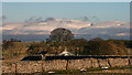
Hardendale
Hardendale with Cross Fell in the background.
Image: © Peter McDermott
Taken: 18 Dec 2011
0.02 miles
3
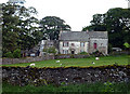
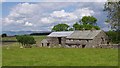
Hardendale Hall
The farmhouse is a Grade II listed building dated 1747 http://www.britishlistedbuildings.co.uk/en-74190
Image: © Karl and Ali
Taken: 13 Jun 2011
0.06 miles
4
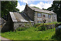
Hardendale Hall
Grade II Listed Building - see https://historicengland.org.uk/listing/the-list/list-entry/1145388
Image: © Ian Taylor
Taken: 7 Jul 2019
0.07 miles
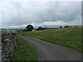
7
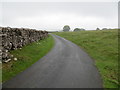
Minor road approaching Hardendale
Looking northward.
Image: © Peter Wood
Taken: 1 Jun 2019
0.13 miles
8
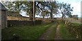
Track from Nook Farm
Rough tractor track from Nook Farm.
Image: © Colin Kinnear
Taken: 22 Oct 2021
0.14 miles
9
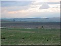
Hardendale Quarry
A vast limestone quarry. It supplies the steel industry, blast furnaces use limestone to remove impurities from the iron.
Image: © Richard Webb
Taken: 13 Feb 2004
0.19 miles
10
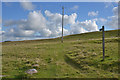
Public footpath heading across Hardendale Nab
Image: © Nigel Brown
Taken: 12 Oct 2015
0.20 miles