IMAGES TAKEN NEAR TO
Shap, PENRITH, CA10 3LG
Introduction
This page details the photographs taken nearby to CA10 3LG by members of the Geograph project.
The Geograph project started in 2005 with the aim of publishing, organising and preserving representative images for every square kilometre of Great Britain, Ireland and the Isle of Man.

There are currently over 7.5m images from over14,400 individuals and you can help contribute to the project by visiting https://www.geograph.org.uk
Image Map
Images are licensed for reuse under creativecommons.org/licenses/by-sa/2.0
Notes
- Clicking on the map will re-center to the selected point.
- The higher the marker number, the further away the image location is from the centre of the postcode.
Image Listing (25 Images Found)
Images are licensed for reuse under creativecommons.org/licenses/by-sa/2.0
Image
Details
Distance
1
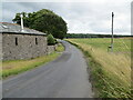
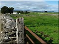
Road at Castlehowe Scar
Looking eastward.
Image: © Peter Wood
Taken: 13 Aug 2021
0.03 miles
2
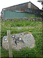
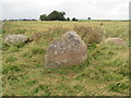
Thunder Stone (east)
Less imposing than its western neighbour down the slope. Somewhat overgrown and rather overshadowed by the great tin shed at nearby Castlehowe Scar.
Image: © Karl and Ali
Taken: 13 Jun 2011
0.04 miles
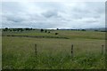
3
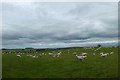
Sheep near Castlehowe Scar
Looking across farmland to the north of Hardendale.
Image: © DS Pugh
Taken: 9 Jul 2020
0.04 miles
4
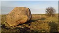
Thunder Stone
This stone was dumped many thousands of years ago by a passing glacier and is composed of granite as opposed to the underlying limestone.
Image: © Colin Kinnear
Taken: 3 Dec 2017
0.06 miles
5
Sheep at Castlehowe Scar farm
About 310 metres above sea level.
Image: © Christine Johnstone
Taken: 15 Sep 2018
0.06 miles
6
Open access farmland at Castlehowe Scar
Sheltering the Thunder Stones and a stone circle.
Image: © Christine Johnstone
Taken: 15 Sep 2018
0.09 miles
7
Farmland near Thunder Stone
Looking across farmland north of Hardendale.
Image: © DS Pugh
Taken: 9 Jul 2020
0.10 miles
8
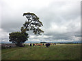
Cows and tree, Castlehowe Scar
The cows were running about like mad things so I let them burn off some energy before moving on. This is exposed, open grassland and the tree has obviously grown away from the prevailing weather.
Image: © Karl and Ali
Taken: 13 Jun 2011
0.12 miles
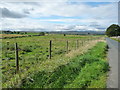
10
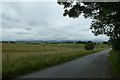
Road near Thunderstone
Looking down the road leading west towards Shap.
Image: © DS Pugh
Taken: 9 Jul 2020
0.13 miles