IMAGES TAKEN NEAR TO
Crosby Ravensworth, PENRITH, CA10 3JG
Introduction
This page details the photographs taken nearby to CA10 3JG by members of the Geograph project.
The Geograph project started in 2005 with the aim of publishing, organising and preserving representative images for every square kilometre of Great Britain, Ireland and the Isle of Man.

There are currently over 7.5m images from over14,400 individuals and you can help contribute to the project by visiting https://www.geograph.org.uk
Image Map
Images are licensed for reuse under creativecommons.org/licenses/by-sa/2.0
Notes
- Clicking on the map will re-center to the selected point.
- The higher the marker number, the further away the image location is from the centre of the postcode.
Image Listing (6 Images Found)
Images are licensed for reuse under creativecommons.org/licenses/by-sa/2.0
Image
Details
Distance
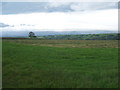
1
Crake Trees
Converted farm above Crosby Ravensworth with a view to Cross Fell and the North Pennines.
Image: © Karl and Ali
Taken: 28 Aug 2011
0.01 miles
2
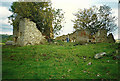
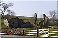
Crake Trees ruin
Derelict buildings near Crake Trees Farm
Image: © Richard Croft
Taken: 1 Oct 1989
0.04 miles
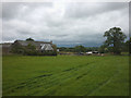
3
Crake Trees Farm & Ruin
Crake Trees Farm near Maulds Meaburn.
Image: © mauldy
Taken: 25 Mar 2007
0.06 miles
4
Ruin
Derelict buildings by Crake Trees Farm.
Image: © mauldy
Taken: 25 Mar 2007
0.07 miles
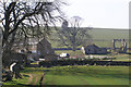
5
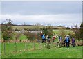
Crossing stiles near Crake Trees
Walkers negotiating no fewer than three stiles close together at a field corner. In the background are the ruins at Crake Trees.
Image: © Jim Barton
Taken: 22 Oct 2014
0.11 miles